You are here: Home > Network List > IU - Global Seismograph Network (GSN - IRIS/USGS) Stations List
> Station MAJO Matsushiro, Japan > Earthquake Result Viewer
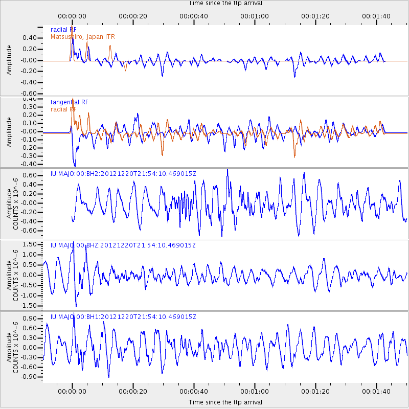
MAJO Matsushiro, Japan - Earthquake Result Viewer
*The percent match for this event was below the threshold and hence no stack was calculated.
| Earthquake location: |
Northern Molucca Sea |
| Earthquake latitude/longitude: |
0.6/126.2 |
| Earthquake time(UTC): |
2012/12/20 (355) 21:47:29 GMT |
| Earthquake Depth: |
28 km |
| Earthquake Magnitude: |
5.7 MB, 4.9 MS, 5.4 MW |
| Earthquake Catalog/Contributor: |
WHDF/NEIC |
|
| Network: |
IU Global Seismograph Network (GSN - IRIS/USGS) |
| Station: |
MAJO Matsushiro, Japan |
| Lat/Lon: |
36.55 N/138.20 E |
| Elevation: |
405 m |
|
| Distance: |
37.5 deg |
| Az: |
15.951 deg |
| Baz: |
199.952 deg |
| Ray Param: |
$rayparam |
*The percent match for this event was below the threshold and hence was not used in the summary stack. |
|
| Radial Match: |
58.333652 % |
| Radial Bump: |
400 |
| Transverse Match: |
60.555965 % |
| Transverse Bump: |
400 |
| SOD ConfigId: |
558545 |
| Insert Time: |
2013-09-18 02:38:17.871 +0000 |
| GWidth: |
2.5 |
| Max Bumps: |
400 |
| Tol: |
0.001 |
|
Signal To Noise
| Channel | StoN | STA | LTA |
| IU:MAJO:00:BHZ:20121220T21:54:10.469015Z | 2.1238499 | 9.1786353E-7 | 4.3216966E-7 |
| IU:MAJO:00:BH1:20121220T21:54:10.469015Z | 1.0066875 | 4.0664813E-7 | 4.0394673E-7 |
| IU:MAJO:00:BH2:20121220T21:54:10.469015Z | 0.78694296 | 1.9298216E-7 | 2.4523018E-7 |
| Arrivals |
| Ps | |
| PpPs | |
| PsPs/PpSs | |


