You are here: Home > Network List > AU - Australian Seismological Centre Stations List
> Station PSAB3 Pilbara Seismic Array Element B3 > Earthquake Result Viewer
PSAB3 Pilbara Seismic Array Element B3 - Earthquake Result Viewer
| Earthquake location: |
Vanuatu Islands |
| Earthquake latitude/longitude: |
-14.3/167.3 |
| Earthquake time(UTC): |
2012/12/21 (356) 22:28:08 GMT |
| Earthquake Depth: |
201 km |
| Earthquake Magnitude: |
6.1 MB, 6.7 MW, 6.7 MW |
| Earthquake Catalog/Contributor: |
WHDF/NEIC |
|
| Network: |
AU Australian Seismological Centre |
| Station: |
PSAB3 Pilbara Seismic Array Element B3 |
| Lat/Lon: |
21.59 S/119.85 E |
| Elevation: |
327 m |
|
| Distance: |
45.6 deg |
| Az: |
253.761 deg |
| Baz: |
89.135 deg |
| Ray Param: |
0.07044922 |
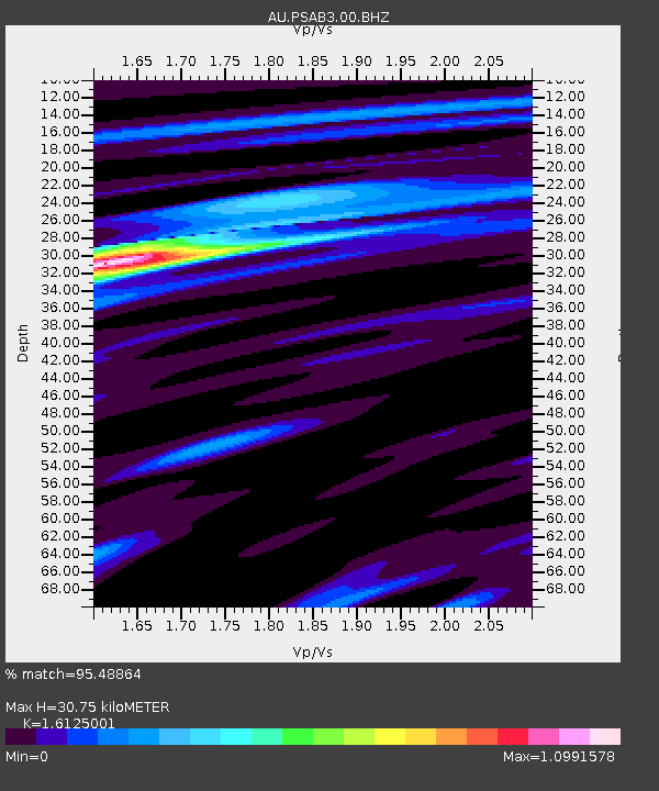
| Estimated Moho Depth: |
30.75 km |
| Estimated Crust Vp/Vs: |
1.61 |
| Assumed Crust Vp: |
6.464 km/s |
| Estimated Crust Vs: |
4.008 km/s |
| Estimated Crust Poisson's Ratio: |
0.19 |
|
| Radial Match: |
95.48864 % |
| Radial Bump: |
285 |
| Transverse Match: |
83.713104 % |
| Transverse Bump: |
400 |
| SOD ConfigId: |
558545 |
| Insert Time: |
2013-09-18 02:39:19.699 +0000 |
| GWidth: |
2.5 |
| Max Bumps: |
400 |
| Tol: |
0.001 |
|

Signal To Noise
| Channel | StoN | STA | LTA |
| AU:PSAB3:00:BHZ:20121221T22:35:37.668999Z | 33.477222 | 7.3765714E-6 | 2.2034598E-7 |
| AU:PSAB3:00:BH1:20121221T22:35:37.668999Z | 34.128685 | 4.3052505E-6 | 1.2614757E-7 |
| AU:PSAB3:00:BH2:20121221T22:35:37.668999Z | 5.275953 | 1.0567443E-6 | 2.0029451E-7 |
| Arrivals |
| Ps | 3.1 SECOND |
| PpPs | 12 SECOND |
| PsPs/PpSs | 15 SECOND |


