You are here: Home > Network List > AU - Australian Seismological Centre Stations List
> Station PSAD1 Pilbara Seismic Array Element D1 > Earthquake Result Viewer
PSAD1 Pilbara Seismic Array Element D1 - Earthquake Result Viewer
| Earthquake location: |
Vanuatu Islands |
| Earthquake latitude/longitude: |
-14.3/167.3 |
| Earthquake time(UTC): |
2012/12/21 (356) 22:28:08 GMT |
| Earthquake Depth: |
201 km |
| Earthquake Magnitude: |
6.1 MB, 6.7 MW, 6.7 MW |
| Earthquake Catalog/Contributor: |
WHDF/NEIC |
|
| Network: |
AU Australian Seismological Centre |
| Station: |
PSAD1 Pilbara Seismic Array Element D1 |
| Lat/Lon: |
21.46 S/119.83 E |
| Elevation: |
280 m |
|
| Distance: |
45.6 deg |
| Az: |
253.954 deg |
| Baz: |
89.279 deg |
| Ray Param: |
0.0704355 |
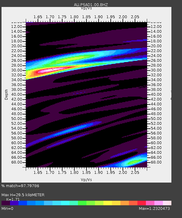
| Estimated Moho Depth: |
29.5 km |
| Estimated Crust Vp/Vs: |
1.71 |
| Assumed Crust Vp: |
6.464 km/s |
| Estimated Crust Vs: |
3.78 km/s |
| Estimated Crust Poisson's Ratio: |
0.24 |
|
| Radial Match: |
97.79786 % |
| Radial Bump: |
263 |
| Transverse Match: |
82.81419 % |
| Transverse Bump: |
400 |
| SOD ConfigId: |
558545 |
| Insert Time: |
2013-09-18 02:39:29.485 +0000 |
| GWidth: |
2.5 |
| Max Bumps: |
400 |
| Tol: |
0.001 |
|

Signal To Noise
| Channel | StoN | STA | LTA |
| AU:PSAD1:00:BHZ:20121221T22:35:37.843987Z | 33.44813 | 7.719986E-6 | 2.3080469E-7 |
| AU:PSAD1:00:BH1:20121221T22:35:37.843987Z | 32.444332 | 4.251503E-6 | 1.3103993E-7 |
| AU:PSAD1:00:BH2:20121221T22:35:37.843987Z | 12.38521 | 1.8348447E-6 | 1.4814805E-7 |
| Arrivals |
| Ps | 3.5 SECOND |
| PpPs | 12 SECOND |
| PsPs/PpSs | 15 SECOND |


