You are here: Home > Network List > IU - Global Seismograph Network (GSN - IRIS/USGS) Stations List
> Station CASY Casey, Antarctica > Earthquake Result Viewer
CASY Casey, Antarctica - Earthquake Result Viewer
| Earthquake location: |
Vanuatu Islands |
| Earthquake latitude/longitude: |
-14.3/167.3 |
| Earthquake time(UTC): |
2012/12/21 (356) 22:28:08 GMT |
| Earthquake Depth: |
201 km |
| Earthquake Magnitude: |
6.1 MB, 6.7 MW, 6.7 MW |
| Earthquake Catalog/Contributor: |
WHDF/NEIC |
|
| Network: |
IU Global Seismograph Network (GSN - IRIS/USGS) |
| Station: |
CASY Casey, Antarctica |
| Lat/Lon: |
66.28 S/110.54 E |
| Elevation: |
10 m |
|
| Distance: |
63.9 deg |
| Az: |
202.134 deg |
| Baz: |
64.513 deg |
| Ray Param: |
0.05867852 |
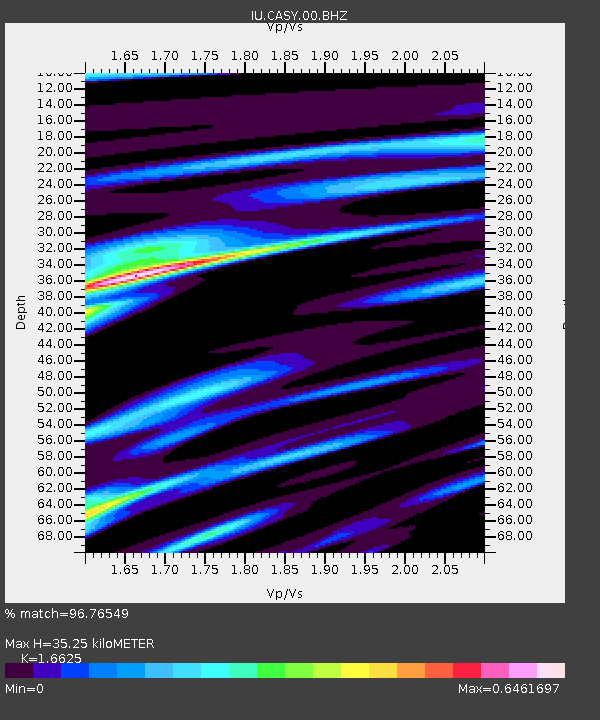
| Estimated Moho Depth: |
35.25 km |
| Estimated Crust Vp/Vs: |
1.66 |
| Assumed Crust Vp: |
6.356 km/s |
| Estimated Crust Vs: |
3.823 km/s |
| Estimated Crust Poisson's Ratio: |
0.22 |
|
| Radial Match: |
96.76549 % |
| Radial Bump: |
378 |
| Transverse Match: |
85.98756 % |
| Transverse Bump: |
400 |
| SOD ConfigId: |
558545 |
| Insert Time: |
2013-09-18 02:40:20.978 +0000 |
| GWidth: |
2.5 |
| Max Bumps: |
400 |
| Tol: |
0.001 |
|

Signal To Noise
| Channel | StoN | STA | LTA |
| IU:CASY:00:BHZ:20121221T22:37:48.968987Z | 62.2628 | 7.308862E-6 | 1.173873E-7 |
| IU:CASY:00:BH1:20121221T22:37:48.968987Z | 22.761494 | 1.8251905E-6 | 8.018764E-8 |
| IU:CASY:00:BH2:20121221T22:37:48.968987Z | 22.440533 | 2.93582E-6 | 1.3082665E-7 |
| Arrivals |
| Ps | 3.8 SECOND |
| PpPs | 14 SECOND |
| PsPs/PpSs | 18 SECOND |


