You are here: Home > Network List > US - United States National Seismic Network Stations List
> Station ELK Elko, Nevada, USA > Earthquake Result Viewer
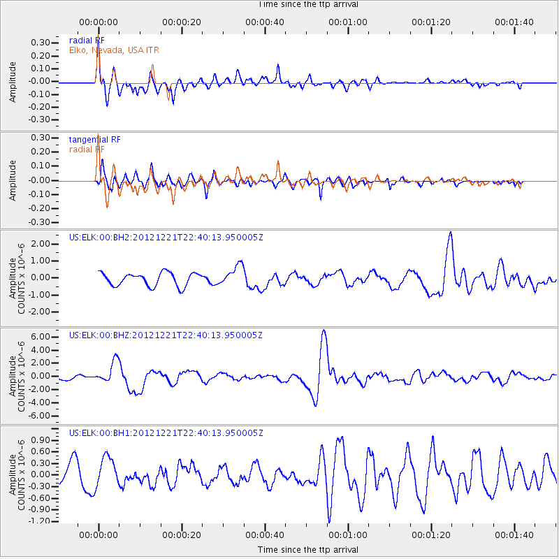
ELK Elko, Nevada, USA - Earthquake Result Viewer
*The percent match for this event was below the threshold and hence no stack was calculated.
| Earthquake location: |
Vanuatu Islands |
| Earthquake latitude/longitude: |
-14.3/167.3 |
| Earthquake time(UTC): |
2012/12/21 (356) 22:28:08 GMT |
| Earthquake Depth: |
201 km |
| Earthquake Magnitude: |
6.1 MB, 6.7 MW, 6.7 MW |
| Earthquake Catalog/Contributor: |
WHDF/NEIC |
|
| Network: |
US United States National Seismic Network |
| Station: |
ELK Elko, Nevada, USA |
| Lat/Lon: |
40.74 N/115.24 W |
| Elevation: |
2210 m |
|
| Distance: |
90.0 deg |
| Az: |
47.877 deg |
| Baz: |
251.113 deg |
| Ray Param: |
$rayparam |
*The percent match for this event was below the threshold and hence was not used in the summary stack. |
|
| Radial Match: |
68.930855 % |
| Radial Bump: |
400 |
| Transverse Match: |
64.50774 % |
| Transverse Bump: |
360 |
| SOD ConfigId: |
558545 |
| Insert Time: |
2013-09-18 02:42:01.112 +0000 |
| GWidth: |
2.5 |
| Max Bumps: |
400 |
| Tol: |
0.001 |
|
Signal To Noise
| Channel | StoN | STA | LTA |
| US:ELK:00:BHZ:20121221T22:40:13.950005Z | 4.578764 | 1.7139663E-6 | 3.7432946E-7 |
| US:ELK:00:BH1:20121221T22:40:13.950005Z | 0.9468422 | 3.8397494E-7 | 4.0553212E-7 |
| US:ELK:00:BH2:20121221T22:40:13.950005Z | 1.5605131 | 6.060766E-7 | 3.8838286E-7 |
| Arrivals |
| Ps | |
| PpPs | |
| PsPs/PpSs | |


