You are here: Home > Network List > US - United States National Seismic Network Stations List
> Station HAWA Hanford, Washington, USA > Earthquake Result Viewer
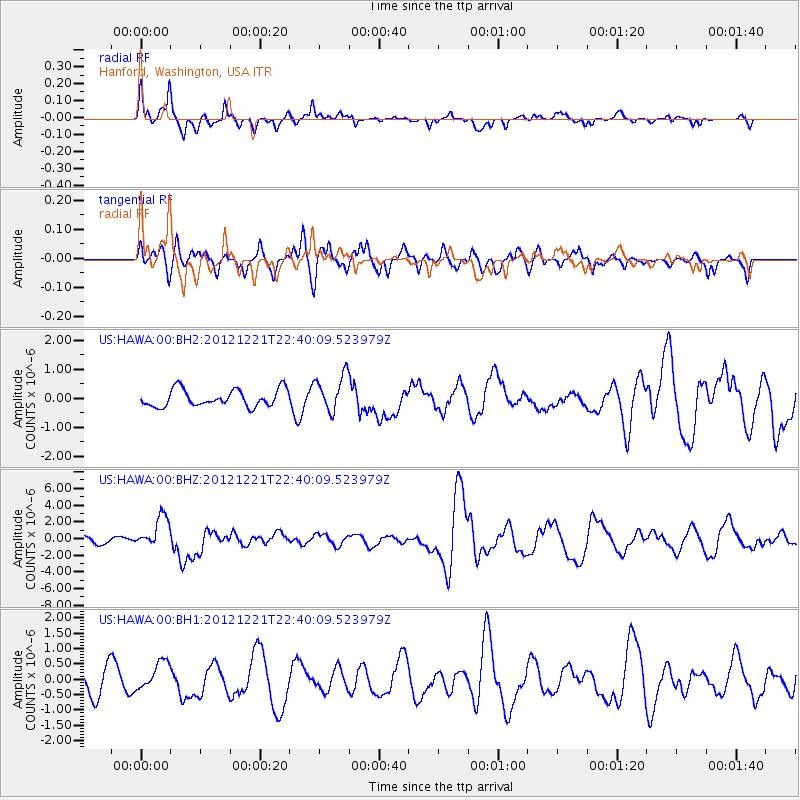
HAWA Hanford, Washington, USA - Earthquake Result Viewer
*The percent match for this event was below the threshold and hence no stack was calculated.
| Earthquake location: |
Vanuatu Islands |
| Earthquake latitude/longitude: |
-14.3/167.3 |
| Earthquake time(UTC): |
2012/12/21 (356) 22:28:08 GMT |
| Earthquake Depth: |
201 km |
| Earthquake Magnitude: |
6.1 MB, 6.7 MW, 6.7 MW |
| Earthquake Catalog/Contributor: |
WHDF/NEIC |
|
| Network: |
US United States National Seismic Network |
| Station: |
HAWA Hanford, Washington, USA |
| Lat/Lon: |
46.39 N/119.53 W |
| Elevation: |
364 m |
|
| Distance: |
89.1 deg |
| Az: |
41.5 deg |
| Baz: |
248.108 deg |
| Ray Param: |
$rayparam |
*The percent match for this event was below the threshold and hence was not used in the summary stack. |
|
| Radial Match: |
64.56609 % |
| Radial Bump: |
337 |
| Transverse Match: |
48.234024 % |
| Transverse Bump: |
379 |
| SOD ConfigId: |
558545 |
| Insert Time: |
2013-09-18 02:42:01.590 +0000 |
| GWidth: |
2.5 |
| Max Bumps: |
400 |
| Tol: |
0.001 |
|
Signal To Noise
| Channel | StoN | STA | LTA |
| US:HAWA:00:BHZ:20121221T22:40:09.523979Z | 3.275585 | 1.8941176E-6 | 5.7825326E-7 |
| US:HAWA:00:BH1:20121221T22:40:09.523979Z | 1.4431667 | 4.718428E-7 | 3.2694962E-7 |
| US:HAWA:00:BH2:20121221T22:40:09.523979Z | 2.1824267 | 6.3761235E-7 | 2.921575E-7 |
| Arrivals |
| Ps | |
| PpPs | |
| PsPs/PpSs | |


