You are here: Home > Network List > US - United States National Seismic Network Stations List
> Station WUAZ Wupatki, Arizona, USA > Earthquake Result Viewer
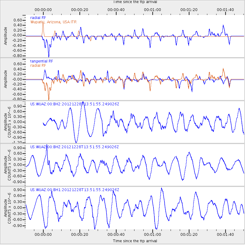
WUAZ Wupatki, Arizona, USA - Earthquake Result Viewer
*The percent match for this event was below the threshold and hence no stack was calculated.
| Earthquake location: |
Komandorskiye Ostrova Region |
| Earthquake latitude/longitude: |
55.7/164.7 |
| Earthquake time(UTC): |
2012/12/28 (363) 13:42:34 GMT |
| Earthquake Depth: |
35 km |
| Earthquake Magnitude: |
5.5 MB, 5.1 MW |
| Earthquake Catalog/Contributor: |
WHDF/NEIC |
|
| Network: |
US United States National Seismic Network |
| Station: |
WUAZ Wupatki, Arizona, USA |
| Lat/Lon: |
35.52 N/111.37 W |
| Elevation: |
1592 m |
|
| Distance: |
58.3 deg |
| Az: |
72.49 deg |
| Baz: |
318.572 deg |
| Ray Param: |
$rayparam |
*The percent match for this event was below the threshold and hence was not used in the summary stack. |
|
| Radial Match: |
74.94013 % |
| Radial Bump: |
400 |
| Transverse Match: |
74.94459 % |
| Transverse Bump: |
364 |
| SOD ConfigId: |
558545 |
| Insert Time: |
2013-09-18 03:04:56.214 +0000 |
| GWidth: |
2.5 |
| Max Bumps: |
400 |
| Tol: |
0.001 |
|
Signal To Noise
| Channel | StoN | STA | LTA |
| US:WUAZ:00:BHZ:20121228T13:51:55.249026Z | 1.5227321 | 4.1701855E-7 | 2.7386207E-7 |
| US:WUAZ:00:BH1:20121228T13:51:55.249026Z | 2.826841 | 6.517526E-7 | 2.3055863E-7 |
| US:WUAZ:00:BH2:20121228T13:51:55.249026Z | 1.1544789 | 6.070768E-7 | 5.258449E-7 |
| Arrivals |
| Ps | |
| PpPs | |
| PsPs/PpSs | |


