You are here: Home > Network List > IU - Global Seismograph Network (GSN - IRIS/USGS) Stations List
> Station HNR Honiara, Solomon Islands > Earthquake Result Viewer
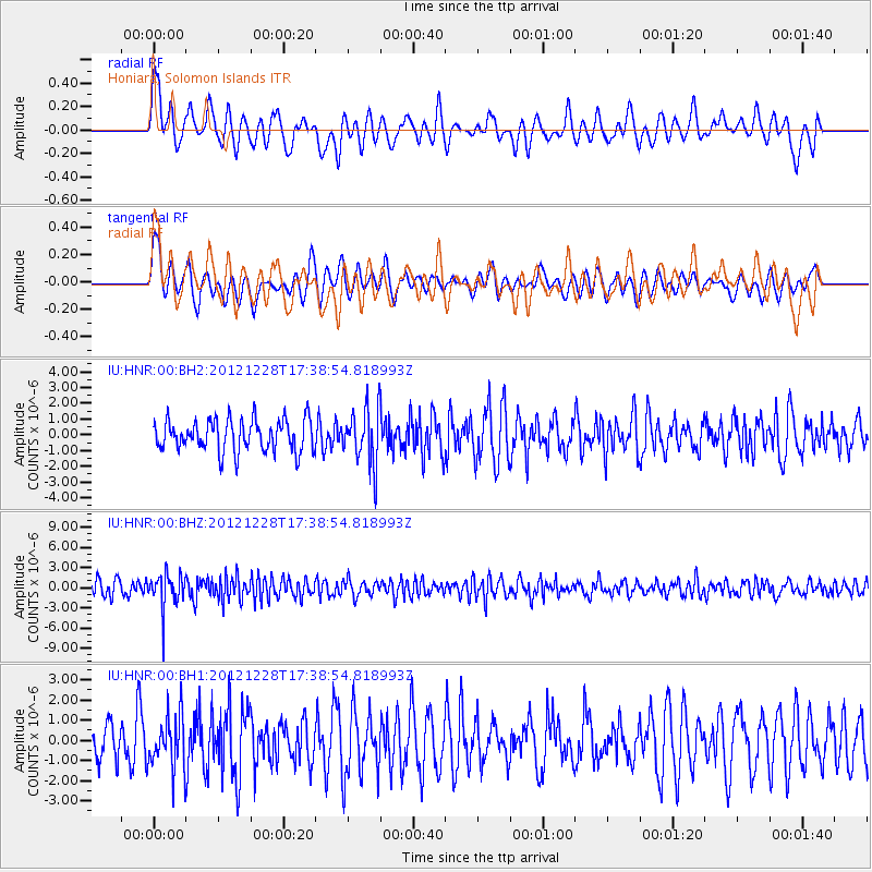
HNR Honiara, Solomon Islands - Earthquake Result Viewer
*The percent match for this event was below the threshold and hence no stack was calculated.
| Earthquake location: |
Minahassa Peninsula, Sulawesi |
| Earthquake latitude/longitude: |
-0.1/122.9 |
| Earthquake time(UTC): |
2012/12/28 (363) 17:32:18 GMT |
| Earthquake Depth: |
112 km |
| Earthquake Magnitude: |
5.5 MW, 5.5 MW |
| Earthquake Catalog/Contributor: |
WHDF/NEIC |
|
| Network: |
IU Global Seismograph Network (GSN - IRIS/USGS) |
| Station: |
HNR Honiara, Solomon Islands |
| Lat/Lon: |
9.44 S/159.95 E |
| Elevation: |
100 m |
|
| Distance: |
38.0 deg |
| Az: |
105.156 deg |
| Baz: |
281.962 deg |
| Ray Param: |
$rayparam |
*The percent match for this event was below the threshold and hence was not used in the summary stack. |
|
| Radial Match: |
62.80606 % |
| Radial Bump: |
399 |
| Transverse Match: |
53.418034 % |
| Transverse Bump: |
400 |
| SOD ConfigId: |
558545 |
| Insert Time: |
2013-09-18 03:05:53.722 +0000 |
| GWidth: |
2.5 |
| Max Bumps: |
400 |
| Tol: |
0.001 |
|
Signal To Noise
| Channel | StoN | STA | LTA |
| IU:HNR:00:BHZ:20121228T17:38:54.818993Z | 2.1214135 | 2.5830507E-6 | 1.2176083E-6 |
| IU:HNR:00:BH1:20121228T17:38:54.818993Z | 1.3159859 | 1.3253883E-6 | 1.0071448E-6 |
| IU:HNR:00:BH2:20121228T17:38:54.818993Z | 1.7769399 | 1.7755634E-6 | 9.992254E-7 |
| Arrivals |
| Ps | |
| PpPs | |
| PsPs/PpSs | |


