You are here: Home > Network List > IU - Global Seismograph Network (GSN - IRIS/USGS) Stations List
> Station JOHN Johnston Island, USA > Earthquake Result Viewer
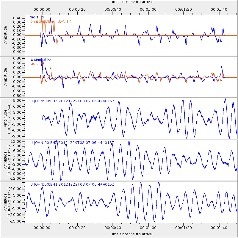
JOHN Johnston Island, USA - Earthquake Result Viewer
*The percent match for this event was below the threshold and hence no stack was calculated.
| Earthquake location: |
Bismarck Sea |
| Earthquake latitude/longitude: |
-3.3/148.8 |
| Earthquake time(UTC): |
2012/12/29 (364) 07:59:15 GMT |
| Earthquake Depth: |
10 km |
| Earthquake Magnitude: |
6.0 MW |
| Earthquake Catalog/Contributor: |
NEIC PDE/NEIC PDE-W |
|
| Network: |
IU Global Seismograph Network (GSN - IRIS/USGS) |
| Station: |
JOHN Johnston Island, USA |
| Lat/Lon: |
16.73 N/169.53 W |
| Elevation: |
2.0 m |
|
| Distance: |
45.8 deg |
| Az: |
62.866 deg |
| Baz: |
248.009 deg |
| Ray Param: |
$rayparam |
*The percent match for this event was below the threshold and hence was not used in the summary stack. |
|
| Radial Match: |
59.69034 % |
| Radial Bump: |
372 |
| Transverse Match: |
62.2857 % |
| Transverse Bump: |
394 |
| SOD ConfigId: |
558545 |
| Insert Time: |
2013-09-18 03:07:39.355 +0000 |
| GWidth: |
2.5 |
| Max Bumps: |
400 |
| Tol: |
0.001 |
|
Signal To Noise
| Channel | StoN | STA | LTA |
| IU:JOHN:00:BHZ:20121229T08:07:06.444015Z | 1.4374514 | 4.717886E-6 | 3.2821188E-6 |
| IU:JOHN:00:BH1:20121229T08:07:06.444015Z | 2.0558915 | 7.735728E-6 | 3.762712E-6 |
| IU:JOHN:00:BH2:20121229T08:07:06.444015Z | 0.7100001 | 2.4538394E-6 | 3.4561112E-6 |
| Arrivals |
| Ps | |
| PpPs | |
| PsPs/PpSs | |


