You are here: Home > Network List > IU - Global Seismograph Network (GSN - IRIS/USGS) Stations List
> Station PMG Port Moresby, New Guinea > Earthquake Result Viewer
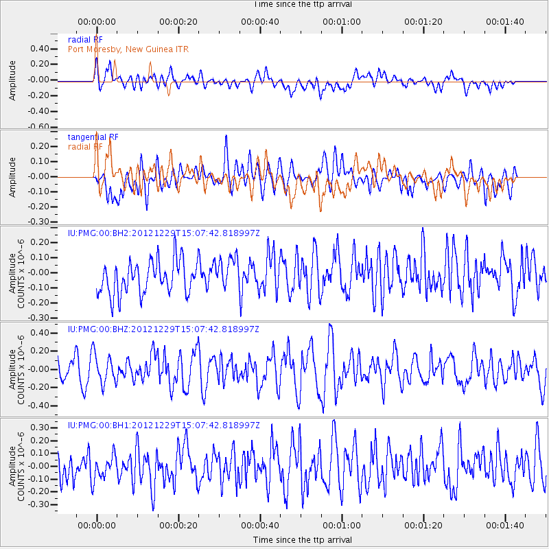
PMG Port Moresby, New Guinea - Earthquake Result Viewer
*The percent match for this event was below the threshold and hence no stack was calculated.
| Earthquake location: |
Near East Coast Of Honshu, Japan |
| Earthquake latitude/longitude: |
38.7/142.0 |
| Earthquake time(UTC): |
2012/12/29 (364) 14:59:38 GMT |
| Earthquake Depth: |
56 km |
| Earthquake Magnitude: |
5.5 MW, 5.4 MW, 5.4 MB |
| Earthquake Catalog/Contributor: |
WHDF/NEIC |
|
| Network: |
IU Global Seismograph Network (GSN - IRIS/USGS) |
| Station: |
PMG Port Moresby, New Guinea |
| Lat/Lon: |
9.40 S/147.16 E |
| Elevation: |
90 m |
|
| Distance: |
48.1 deg |
| Az: |
173.188 deg |
| Baz: |
354.606 deg |
| Ray Param: |
$rayparam |
*The percent match for this event was below the threshold and hence was not used in the summary stack. |
|
| Radial Match: |
50.033607 % |
| Radial Bump: |
400 |
| Transverse Match: |
44.075115 % |
| Transverse Bump: |
400 |
| SOD ConfigId: |
558545 |
| Insert Time: |
2013-09-18 03:10:35.113 +0000 |
| GWidth: |
2.5 |
| Max Bumps: |
400 |
| Tol: |
0.001 |
|
Signal To Noise
| Channel | StoN | STA | LTA |
| IU:PMG:00:BHZ:20121229T15:07:42.818997Z | 1.1819733 | 1.5570812E-7 | 1.3173573E-7 |
| IU:PMG:00:BH1:20121229T15:07:42.818997Z | 0.7710649 | 9.978474E-8 | 1.294116E-7 |
| IU:PMG:00:BH2:20121229T15:07:42.818997Z | 0.9980406 | 1.0764397E-7 | 1.0785529E-7 |
| Arrivals |
| Ps | |
| PpPs | |
| PsPs/PpSs | |


