You are here: Home > Network List > CN - Canadian National Seismograph Network Stations List
> Station DRLN Deer Lake, NFLD. > Earthquake Result Viewer
DRLN Deer Lake, NFLD. - Earthquake Result Viewer
| Earthquake location: |
Guerrero, Mexico |
| Earthquake latitude/longitude: |
17.6/-101.0 |
| Earthquake time(UTC): |
1996/07/15 (197) 21:23:34 GMT |
| Earthquake Depth: |
18 km |
| Earthquake Magnitude: |
5.7 MB, 6.5 MS, 6.6 UNKNOWN, 6.2 ME |
| Earthquake Catalog/Contributor: |
WHDF/NEIC |
|
| Network: |
CN Canadian National Seismograph Network |
| Station: |
DRLN Deer Lake, NFLD. |
| Lat/Lon: |
49.26 N/57.50 W |
| Elevation: |
238 m |
|
| Distance: |
47.1 deg |
| Az: |
37.963 deg |
| Baz: |
243.57 deg |
| Ray Param: |
0.070188425 |
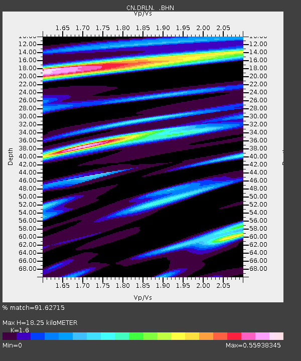
| Estimated Moho Depth: |
18.25 km |
| Estimated Crust Vp/Vs: |
1.60 |
| Assumed Crust Vp: |
6.35 km/s |
| Estimated Crust Vs: |
3.969 km/s |
| Estimated Crust Poisson's Ratio: |
0.18 |
|
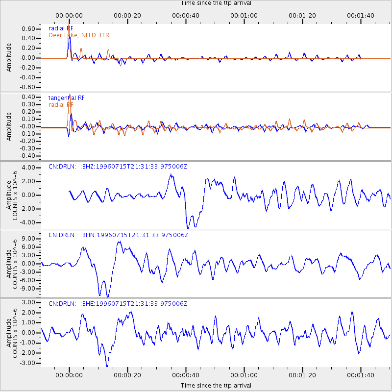
| Radial Match: |
91.62715 % |
| Radial Bump: |
341 |
| Transverse Match: |
72.15939 % |
| Transverse Bump: |
400 |
| SOD ConfigId: |
4480 |
| Insert Time: |
2010-02-27 05:32:01.894 +0000 |
| GWidth: |
2.5 |
| Max Bumps: |
400 |
| Tol: |
0.001 |
|
Signal To Noise
| Channel | StoN | STA | LTA |
| CN:DRLN: :BHN:19960715T21:31:33.975006Z | 2.7034917 | 2.4982605E-6 | 9.2408663E-7 |
| CN:DRLN: :BHE:19960715T21:31:33.975006Z | 1.5352552 | 7.9098413E-7 | 5.1521346E-7 |
| CN:DRLN: :BHZ:19960715T21:31:33.975006Z | 2.4538345 | 1.1268879E-6 | 4.592355E-7 |
| Arrivals |
| Ps | 1.8 SECOND |
| PpPs | 7.0 SECOND |
| PsPs/PpSs | 8.8 SECOND |


