You are here: Home > Network List > IU - Global Seismograph Network (GSN - IRIS/USGS) Stations List
> Station OTAV Otavalo, Ecuador > Earthquake Result Viewer
OTAV Otavalo, Ecuador - Earthquake Result Viewer
| Earthquake location: |
Southeastern Alaska |
| Earthquake latitude/longitude: |
55.4/-134.7 |
| Earthquake time(UTC): |
2013/01/05 (005) 08:58:19 GMT |
| Earthquake Depth: |
10 km |
| Earthquake Magnitude: |
6.4 MB, 7.7 MS, 7.5 MW, 7.5 MW |
| Earthquake Catalog/Contributor: |
WHDF/NEIC |
|
| Network: |
IU Global Seismograph Network (GSN - IRIS/USGS) |
| Station: |
OTAV Otavalo, Ecuador |
| Lat/Lon: |
0.24 N/78.45 W |
| Elevation: |
3510 m |
|
| Distance: |
71.3 deg |
| Az: |
118.676 deg |
| Baz: |
329.963 deg |
| Ray Param: |
0.054426216 |
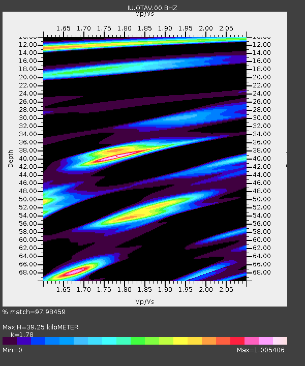
| Estimated Moho Depth: |
39.25 km |
| Estimated Crust Vp/Vs: |
1.78 |
| Assumed Crust Vp: |
6.472 km/s |
| Estimated Crust Vs: |
3.636 km/s |
| Estimated Crust Poisson's Ratio: |
0.27 |
|
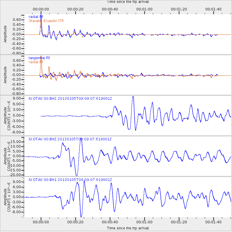
| Radial Match: |
97.98459 % |
| Radial Bump: |
358 |
| Transverse Match: |
91.92141 % |
| Transverse Bump: |
400 |
| SOD ConfigId: |
558545 |
| Insert Time: |
2013-09-18 03:27:49.800 +0000 |
| GWidth: |
2.5 |
| Max Bumps: |
400 |
| Tol: |
0.001 |
|
Signal To Noise
| Channel | StoN | STA | LTA |
| IU:OTAV:00:BHZ:20130105T09:09:07.619001Z | 5.5200276 | 5.9663137E-7 | 1.0808484E-7 |
| IU:OTAV:00:BH1:20130105T09:09:07.619001Z | 2.3148396 | 2.683715E-7 | 1.1593525E-7 |
| IU:OTAV:00:BH2:20130105T09:09:07.619001Z | 1.632153 | 1.6993124E-7 | 1.0411477E-7 |
| Arrivals |
| Ps | 4.9 SECOND |
| PpPs | 16 SECOND |
| PsPs/PpSs | 21 SECOND |


