You are here: Home > Network List > II - Global Seismograph Network (GSN - IRIS/IDA) Stations List
> Station TAU Hobart, Tasmania, Australia > Earthquake Result Viewer
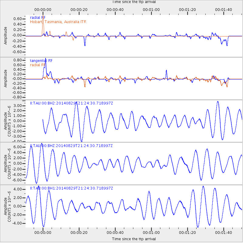
TAU Hobart, Tasmania, Australia - Earthquake Result Viewer
*The percent match for this event was below the threshold and hence no stack was calculated.
| Earthquake location: |
Southeast Indian Ridge |
| Earthquake latitude/longitude: |
-41.9/84.7 |
| Earthquake time(UTC): |
2014/08/29 (241) 21:16:44 GMT |
| Earthquake Depth: |
10 km |
| Earthquake Magnitude: |
5.5 MWB, 5.5 MWC |
| Earthquake Catalog/Contributor: |
NEIC PDE/NEIC COMCAT |
|
| Network: |
II Global Seismograph Network (GSN - IRIS/IDA) |
| Station: |
TAU Hobart, Tasmania, Australia |
| Lat/Lon: |
42.91 S/147.32 E |
| Elevation: |
132 m |
|
| Distance: |
45.2 deg |
| Az: |
113.304 deg |
| Baz: |
248.872 deg |
| Ray Param: |
$rayparam |
*The percent match for this event was below the threshold and hence was not used in the summary stack. |
|
| Radial Match: |
68.11215 % |
| Radial Bump: |
400 |
| Transverse Match: |
88.26246 % |
| Transverse Bump: |
400 |
| SOD ConfigId: |
3390531 |
| Insert Time: |
2019-04-13 17:22:01.683 +0000 |
| GWidth: |
2.5 |
| Max Bumps: |
400 |
| Tol: |
0.001 |
|
Signal To Noise
| Channel | StoN | STA | LTA |
| II:TAU:00:BHZ:20140829T21:24:30.718997Z | 1.6218033 | 4.6143396E-6 | 2.8451905E-6 |
| II:TAU:00:BH1:20140829T21:24:30.718997Z | 1.9420431 | 3.0346937E-6 | 1.5626294E-6 |
| II:TAU:00:BH2:20140829T21:24:30.718997Z | 0.8114951 | 1.5314469E-6 | 1.8871917E-6 |
| Arrivals |
| Ps | |
| PpPs | |
| PsPs/PpSs | |


