You are here: Home > Network List > US - United States National Seismic Network Stations List
> Station AMTX Amarillo, Texas, USA > Earthquake Result Viewer
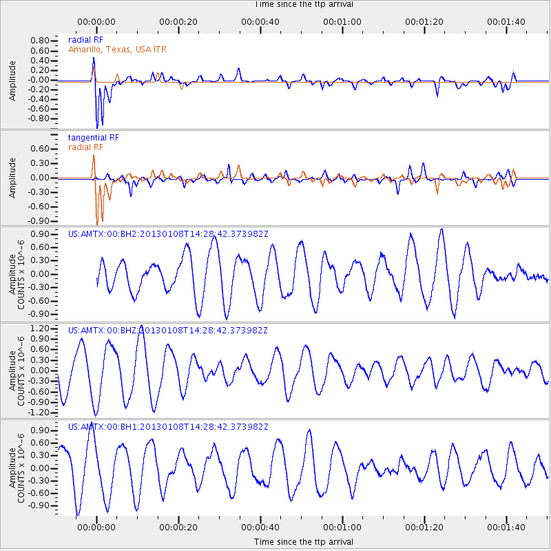
AMTX Amarillo, Texas, USA - Earthquake Result Viewer
*The percent match for this event was below the threshold and hence no stack was calculated.
| Earthquake location: |
Aegean Sea |
| Earthquake latitude/longitude: |
39.7/25.5 |
| Earthquake time(UTC): |
2013/01/08 (008) 14:16:08 GMT |
| Earthquake Depth: |
13 km |
| Earthquake Magnitude: |
5.7 MB, 5.8 MS, 5.7 MW, 5.7 MW |
| Earthquake Catalog/Contributor: |
WHDF/NEIC |
|
| Network: |
US United States National Seismic Network |
| Station: |
AMTX Amarillo, Texas, USA |
| Lat/Lon: |
34.53 N/101.41 W |
| Elevation: |
1010 m |
|
| Distance: |
91.4 deg |
| Az: |
318.7 deg |
| Baz: |
38.108 deg |
| Ray Param: |
$rayparam |
*The percent match for this event was below the threshold and hence was not used in the summary stack. |
|
| Radial Match: |
86.84322 % |
| Radial Bump: |
400 |
| Transverse Match: |
75.31018 % |
| Transverse Bump: |
400 |
| SOD ConfigId: |
558545 |
| Insert Time: |
2013-09-18 03:45:02.213 +0000 |
| GWidth: |
2.5 |
| Max Bumps: |
400 |
| Tol: |
0.001 |
|
Signal To Noise
| Channel | StoN | STA | LTA |
| US:AMTX:00:BHZ:20130108T14:28:42.373982Z | 1.5508639 | 8.0597164E-7 | 5.1969204E-7 |
| US:AMTX:00:BH1:20130108T14:28:42.373982Z | 1.1339053 | 6.127505E-7 | 5.403895E-7 |
| US:AMTX:00:BH2:20130108T14:28:42.373982Z | 1.4476275 | 5.2929545E-7 | 3.6562957E-7 |
| Arrivals |
| Ps | |
| PpPs | |
| PsPs/PpSs | |


