You are here: Home > Network List > US - United States National Seismic Network Stations List
> Station DGMT Dagmar, Montana, USA > Earthquake Result Viewer
DGMT Dagmar, Montana, USA - Earthquake Result Viewer
*The percent match for this event was below the threshold and hence no stack was calculated.
| Earthquake location: |
Aegean Sea |
| Earthquake latitude/longitude: |
39.7/25.5 |
| Earthquake time(UTC): |
2013/01/08 (008) 14:16:08 GMT |
| Earthquake Depth: |
13 km |
| Earthquake Magnitude: |
5.7 MB, 5.8 MS, 5.7 MW, 5.7 MW |
| Earthquake Catalog/Contributor: |
WHDF/NEIC |
|
| Network: |
US United States National Seismic Network |
| Station: |
DGMT Dagmar, Montana, USA |
| Lat/Lon: |
48.47 N/104.20 W |
| Elevation: |
0.0 m |
|
| Distance: |
81.6 deg |
| Az: |
328.847 deg |
| Baz: |
36.877 deg |
| Ray Param: |
$rayparam |
*The percent match for this event was below the threshold and hence was not used in the summary stack. |
|
| Radial Match: |
73.2824 % |
| Radial Bump: |
400 |
| Transverse Match: |
80.96081 % |
| Transverse Bump: |
354 |
| SOD ConfigId: |
558545 |
| Insert Time: |
2013-09-18 03:45:24.106 +0000 |
| GWidth: |
2.5 |
| Max Bumps: |
400 |
| Tol: |
0.001 |
|
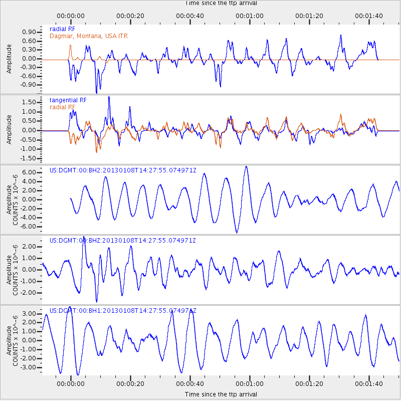
Signal To Noise
| Channel | StoN | STA | LTA |
| US:DGMT:00:BHZ:20130108T14:27:55.074971Z | 3.2881284 | 1.5099305E-6 | 4.592067E-7 |
| US:DGMT:00:BH1:20130108T14:27:55.074971Z | 1.5714911 | 2.7375586E-6 | 1.7420134E-6 |
| US:DGMT:00:BH2:20130108T14:27:55.074971Z | 0.77544063 | 2.0858788E-6 | 2.689927E-6 |
| Arrivals |
| Ps | |
| PpPs | |
| PsPs/PpSs | |


