You are here: Home > Network List > II - Global Seismograph Network (GSN - IRIS/IDA) Stations List
> Station WRAB Tennant Creek, NT, Australia > Earthquake Result Viewer
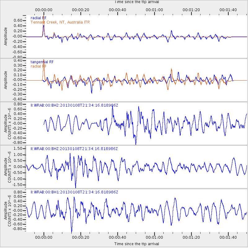
WRAB Tennant Creek, NT, Australia - Earthquake Result Viewer
*The percent match for this event was below the threshold and hence no stack was calculated.
| Earthquake location: |
South Of Kermadec Islands |
| Earthquake latitude/longitude: |
-34.6/179.2 |
| Earthquake time(UTC): |
2013/01/08 (008) 21:26:55 GMT |
| Earthquake Depth: |
10 km |
| Earthquake Magnitude: |
5.7 MW, 5.6 MW |
| Earthquake Catalog/Contributor: |
NEIC PDE/NEIC PDE-W |
|
| Network: |
II Global Seismograph Network (GSN - IRIS/IDA) |
| Station: |
WRAB Tennant Creek, NT, Australia |
| Lat/Lon: |
19.93 S/134.36 E |
| Elevation: |
366 m |
|
| Distance: |
42.1 deg |
| Az: |
278.378 deg |
| Baz: |
119.838 deg |
| Ray Param: |
$rayparam |
*The percent match for this event was below the threshold and hence was not used in the summary stack. |
|
| Radial Match: |
66.80548 % |
| Radial Bump: |
322 |
| Transverse Match: |
43.82141 % |
| Transverse Bump: |
269 |
| SOD ConfigId: |
558545 |
| Insert Time: |
2013-09-18 03:47:35.111 +0000 |
| GWidth: |
2.5 |
| Max Bumps: |
400 |
| Tol: |
0.001 |
|
Signal To Noise
| Channel | StoN | STA | LTA |
| II:WRAB:00:BHZ:20130108T21:34:16.818986Z | 3.5662403 | 4.8078823E-7 | 1.3481656E-7 |
| II:WRAB:00:BH1:20130108T21:34:16.818986Z | 0.8532797 | 2.5105734E-7 | 2.942263E-7 |
| II:WRAB:00:BH2:20130108T21:34:16.818986Z | 0.78599715 | 1.6202576E-7 | 2.0614038E-7 |
| Arrivals |
| Ps | |
| PpPs | |
| PsPs/PpSs | |


