You are here: Home > Network List > IU - Global Seismograph Network (GSN - IRIS/USGS) Stations List
> Station GNI Garni, Armenia > Earthquake Result Viewer
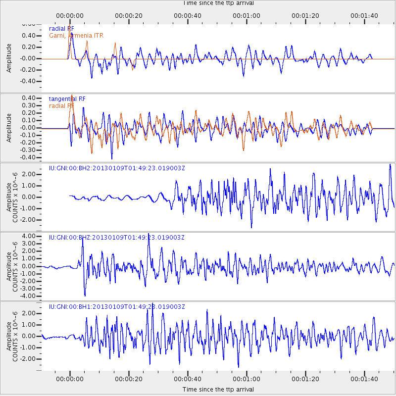
GNI Garni, Armenia - Earthquake Result Viewer
*The percent match for this event was below the threshold and hence no stack was calculated.
| Earthquake location: |
Myanmar-India Border Region |
| Earthquake latitude/longitude: |
25.3/95.0 |
| Earthquake time(UTC): |
2013/01/09 (009) 01:41:53 GMT |
| Earthquake Depth: |
93 km |
| Earthquake Magnitude: |
5.8 MB, 5.8 MW, 5.8 MW |
| Earthquake Catalog/Contributor: |
WHDF/NEIC |
|
| Network: |
IU Global Seismograph Network (GSN - IRIS/USGS) |
| Station: |
GNI Garni, Armenia |
| Lat/Lon: |
40.15 N/44.74 E |
| Elevation: |
1609 m |
|
| Distance: |
44.3 deg |
| Az: |
302.303 deg |
| Baz: |
93.703 deg |
| Ray Param: |
$rayparam |
*The percent match for this event was below the threshold and hence was not used in the summary stack. |
|
| Radial Match: |
75.74277 % |
| Radial Bump: |
400 |
| Transverse Match: |
81.66231 % |
| Transverse Bump: |
400 |
| SOD ConfigId: |
558545 |
| Insert Time: |
2013-09-18 03:51:01.651 +0000 |
| GWidth: |
2.5 |
| Max Bumps: |
400 |
| Tol: |
0.001 |
|
Signal To Noise
| Channel | StoN | STA | LTA |
| IU:GNI:00:BHZ:20130109T01:49:23.019003Z | 10.856713 | 1.1187159E-6 | 1.030437E-7 |
| IU:GNI:00:BH1:20130109T01:49:23.019003Z | 1.1547945 | 1.7184988E-7 | 1.4881425E-7 |
| IU:GNI:00:BH2:20130109T01:49:23.019003Z | 3.1570122 | 3.9356604E-7 | 1.2466408E-7 |
| Arrivals |
| Ps | |
| PpPs | |
| PsPs/PpSs | |


