You are here: Home > Network List > IU - Global Seismograph Network (GSN - IRIS/USGS) Stations List
> Station HNR Honiara, Solomon Islands > Earthquake Result Viewer
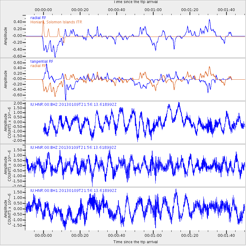
HNR Honiara, Solomon Islands - Earthquake Result Viewer
*The percent match for this event was below the threshold and hence no stack was calculated.
| Earthquake location: |
Pacific-Antarctic Ridge |
| Earthquake latitude/longitude: |
-57.0/-141.5 |
| Earthquake time(UTC): |
2013/01/09 (009) 21:46:02 GMT |
| Earthquake Depth: |
10 km |
| Earthquake Magnitude: |
5.6 MW, 5.0 MS, 5.3 MB, 5.5 MW |
| Earthquake Catalog/Contributor: |
WHDF/NEIC |
|
| Network: |
IU Global Seismograph Network (GSN - IRIS/USGS) |
| Station: |
HNR Honiara, Solomon Islands |
| Lat/Lon: |
9.44 S/159.95 E |
| Elevation: |
100 m |
|
| Distance: |
65.3 deg |
| Az: |
292.083 deg |
| Baz: |
149.119 deg |
| Ray Param: |
$rayparam |
*The percent match for this event was below the threshold and hence was not used in the summary stack. |
|
| Radial Match: |
26.228418 % |
| Radial Bump: |
400 |
| Transverse Match: |
41.632378 % |
| Transverse Bump: |
400 |
| SOD ConfigId: |
558545 |
| Insert Time: |
2013-09-18 03:53:47.733 +0000 |
| GWidth: |
2.5 |
| Max Bumps: |
400 |
| Tol: |
0.001 |
|
Signal To Noise
| Channel | StoN | STA | LTA |
| IU:HNR:00:BHZ:20130109T21:56:13.618992Z | 1.6309326 | 6.380649E-7 | 3.91227E-7 |
| IU:HNR:00:BH1:20130109T21:56:13.618992Z | 1.702117 | 9.932292E-7 | 5.8352583E-7 |
| IU:HNR:00:BH2:20130109T21:56:13.618992Z | 1.2772537 | 7.25605E-7 | 5.680978E-7 |
| Arrivals |
| Ps | |
| PpPs | |
| PsPs/PpSs | |


