You are here: Home > Network List > CN - Canadian National Seismograph Network Stations List
> Station DRLN Deer Lake, NFLD. > Earthquake Result Viewer
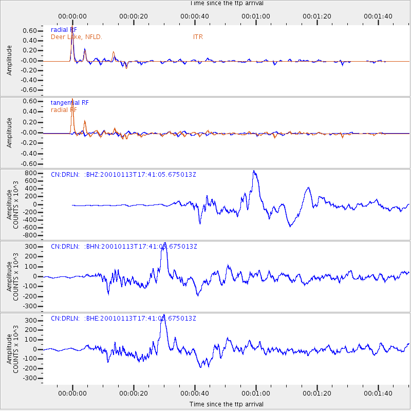
DRLN Deer Lake, NFLD. - Earthquake Result Viewer

| Earthquake location: |
El Salvador |
| Earthquake latitude/longitude: |
13.0/-88.7 |
| Earthquake time(UTC): |
2001/01/13 (013) 17:33:32 GMT |
| Earthquake Depth: |
60 km |
| Earthquake Magnitude: |
6.4 MB, 7.8 MS, 7.7 MW, 7.5 ME |
| Earthquake Catalog/Contributor: |
WHDF/NEIC |
|
| Network: |
CN Canadian National Seismograph Network |
| Station: |
DRLN Deer Lake, NFLD. |
| Lat/Lon: |
49.26 N/57.50 W |
| Elevation: |
238 m |
|
| Distance: |
44.3 deg |
| Az: |
29.044 deg |
| Baz: |
226.228 deg |
| Ray Param: |
0.07184165 |
| Estimated Moho Depth: |
34.5 km |
| Estimated Crust Vp/Vs: |
1.71 |
| Assumed Crust Vp: |
6.35 km/s |
| Estimated Crust Vs: |
3.719 km/s |
| Estimated Crust Poisson's Ratio: |
0.24 |
|
| Radial Match: |
97.793335 % |
| Radial Bump: |
289 |
| Transverse Match: |
83.293106 % |
| Transverse Bump: |
400 |
| SOD ConfigId: |
3744 |
| Insert Time: |
2010-02-27 05:33:18.906 +0000 |
| GWidth: |
2.5 |
| Max Bumps: |
400 |
| Tol: |
0.001 |
|
Signal To Noise
| Channel | StoN | STA | LTA |
| CN:DRLN: :BHN:20010113T17:41:05.675013Z | 2.3427005 | 12692.175 | 5417.754 |
| CN:DRLN: :BHE:20010113T17:41:05.675013Z | 2.9083924 | 18149.06 | 6240.238 |
| CN:DRLN: :BHZ:20010113T17:41:05.675013Z | 4.710152 | 45014.383 | 9556.885 |
| Arrivals |
| Ps | 4.1 SECOND |
| PpPs | 14 SECOND |
| PsPs/PpSs | 18 SECOND |


