You are here: Home > Network List > IU - Global Seismograph Network (GSN - IRIS/USGS) Stations List
> Station HNR Honiara, Solomon Islands > Earthquake Result Viewer
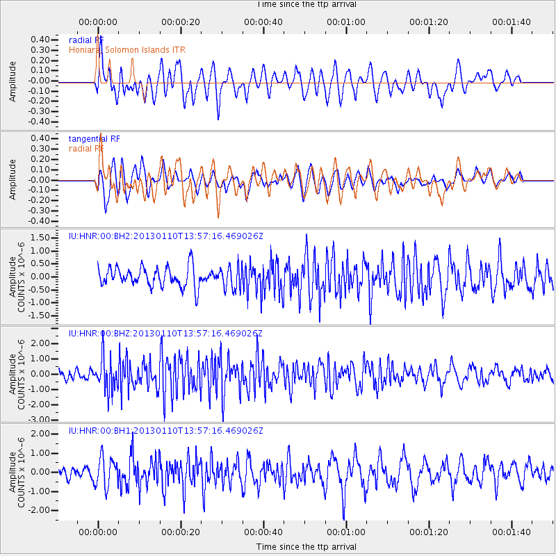
HNR Honiara, Solomon Islands - Earthquake Result Viewer
*The percent match for this event was below the threshold and hence no stack was calculated.
| Earthquake location: |
Northern Sumatra, Indonesia |
| Earthquake latitude/longitude: |
4.7/95.1 |
| Earthquake time(UTC): |
2013/01/10 (010) 13:47:03 GMT |
| Earthquake Depth: |
38 km |
| Earthquake Magnitude: |
5.9 MB, 5.5 MS, 5.7 MW, 5.7 MW |
| Earthquake Catalog/Contributor: |
WHDF/NEIC |
|
| Network: |
IU Global Seismograph Network (GSN - IRIS/USGS) |
| Station: |
HNR Honiara, Solomon Islands |
| Lat/Lon: |
9.44 S/159.95 E |
| Elevation: |
100 m |
|
| Distance: |
66.1 deg |
| Az: |
102.417 deg |
| Baz: |
279.418 deg |
| Ray Param: |
$rayparam |
*The percent match for this event was below the threshold and hence was not used in the summary stack. |
|
| Radial Match: |
58.811096 % |
| Radial Bump: |
400 |
| Transverse Match: |
72.87802 % |
| Transverse Bump: |
400 |
| SOD ConfigId: |
558545 |
| Insert Time: |
2013-09-18 03:58:07.699 +0000 |
| GWidth: |
2.5 |
| Max Bumps: |
400 |
| Tol: |
0.001 |
|
Signal To Noise
| Channel | StoN | STA | LTA |
| IU:HNR:00:BHZ:20130110T13:57:16.469026Z | 3.3376224 | 1.0927316E-6 | 3.273982E-7 |
| IU:HNR:00:BH1:20130110T13:57:16.469026Z | 2.3419335 | 7.807687E-7 | 3.3338637E-7 |
| IU:HNR:00:BH2:20130110T13:57:16.469026Z | 1.1558949 | 4.4378478E-7 | 3.839318E-7 |
| Arrivals |
| Ps | |
| PpPs | |
| PsPs/PpSs | |


