You are here: Home > Network List > CN - Canadian National Seismograph Network Stations List
> Station DRLN Deer Lake, NFLD. > Earthquake Result Viewer
DRLN Deer Lake, NFLD. - Earthquake Result Viewer
| Earthquake location: |
Near Coast Of Peru |
| Earthquake latitude/longitude: |
-17.5/-72.1 |
| Earthquake time(UTC): |
2001/07/07 (188) 09:38:43 GMT |
| Earthquake Depth: |
33 km |
| Earthquake Magnitude: |
6.6 MB, 7.3 MS, 7.6 MW, 7.5 ME |
| Earthquake Catalog/Contributor: |
WHDF/NEIC |
|
| Network: |
CN Canadian National Seismograph Network |
| Station: |
DRLN Deer Lake, NFLD. |
| Lat/Lon: |
49.26 N/57.50 W |
| Elevation: |
238 m |
|
| Distance: |
67.7 deg |
| Az: |
10.26 deg |
| Baz: |
195.033 deg |
| Ray Param: |
0.056702755 |
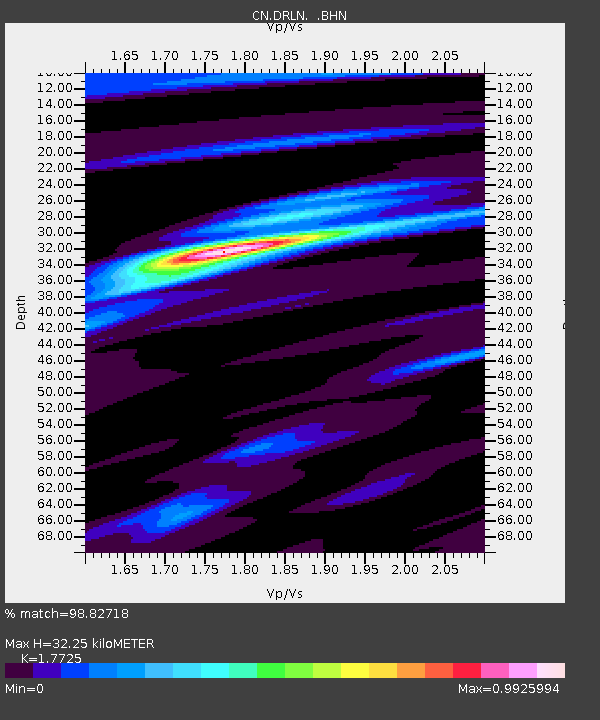
| Estimated Moho Depth: |
32.25 km |
| Estimated Crust Vp/Vs: |
1.77 |
| Assumed Crust Vp: |
6.35 km/s |
| Estimated Crust Vs: |
3.583 km/s |
| Estimated Crust Poisson's Ratio: |
0.27 |
|
| Radial Match: |
98.82718 % |
| Radial Bump: |
209 |
| Transverse Match: |
95.86627 % |
| Transverse Bump: |
400 |
| SOD ConfigId: |
4714 |
| Insert Time: |
2010-02-27 05:33:35.577 +0000 |
| GWidth: |
2.5 |
| Max Bumps: |
400 |
| Tol: |
0.001 |
|

Signal To Noise
| Channel | StoN | STA | LTA |
| CN:DRLN: :BHN:20010707T09:49:06.949016Z | 7.638546 | 9187.862 | 1202.8286 |
| CN:DRLN: :BHE:20010707T09:49:06.949016Z | 2.080969 | 2906.7869 | 1396.8429 |
| CN:DRLN: :BHZ:20010707T09:49:06.949016Z | 11.814737 | 25231.97 | 2135.6355 |
| Arrivals |
| Ps | 4.1 SECOND |
| PpPs | 14 SECOND |
| PsPs/PpSs | 18 SECOND |


