You are here: Home > Network List > US - United States National Seismic Network Stations List
> Station BMO Blue Mountains Array (Baker), Oregon, USA > Earthquake Result Viewer
BMO Blue Mountains Array (Baker), Oregon, USA - Earthquake Result Viewer
| Earthquake location: |
Taiwan Region |
| Earthquake latitude/longitude: |
24.8/122.5 |
| Earthquake time(UTC): |
2013/01/20 (020) 19:09:45 GMT |
| Earthquake Depth: |
114 km |
| Earthquake Magnitude: |
5.5 ML |
| Earthquake Catalog/Contributor: |
NEIC PDE/NEIC PDE-W |
|
| Network: |
US United States National Seismic Network |
| Station: |
BMO Blue Mountains Array (Baker), Oregon, USA |
| Lat/Lon: |
44.85 N/117.31 W |
| Elevation: |
1189 m |
|
| Distance: |
91.8 deg |
| Az: |
37.981 deg |
| Baz: |
308.142 deg |
| Ray Param: |
0.041501097 |
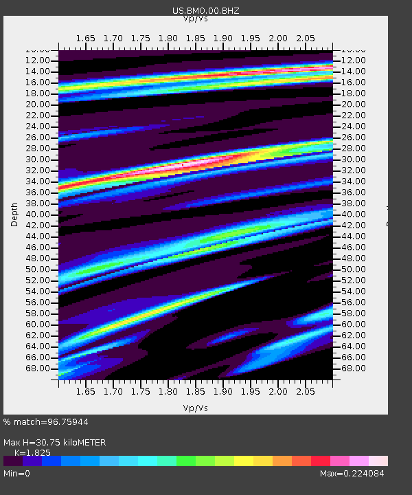
| Estimated Moho Depth: |
30.75 km |
| Estimated Crust Vp/Vs: |
1.83 |
| Assumed Crust Vp: |
6.571 km/s |
| Estimated Crust Vs: |
3.6 km/s |
| Estimated Crust Poisson's Ratio: |
0.29 |
|
| Radial Match: |
96.75944 % |
| Radial Bump: |
182 |
| Transverse Match: |
71.67886 % |
| Transverse Bump: |
365 |
| SOD ConfigId: |
558545 |
| Insert Time: |
2013-09-18 04:31:18.129 +0000 |
| GWidth: |
2.5 |
| Max Bumps: |
400 |
| Tol: |
0.001 |
|

Signal To Noise
| Channel | StoN | STA | LTA |
| US:BMO:00:BHZ:20130120T19:22:09.724014Z | 0.33145016 | 6.1602044E-8 | 1.8585612E-7 |
| US:BMO:00:BH1:20130120T19:22:09.724014Z | 0.9790103 | 1.3190103E-7 | 1.3472896E-7 |
| US:BMO:00:BH2:20130120T19:22:09.724014Z | 0.37102166 | 4.4116117E-8 | 1.18904424E-7 |
| Arrivals |
| Ps | 3.9 SECOND |
| PpPs | 13 SECOND |
| PsPs/PpSs | 17 SECOND |


