You are here: Home > Network List > US - United States National Seismic Network Stations List
> Station DGMT Dagmar, Montana, USA > Earthquake Result Viewer
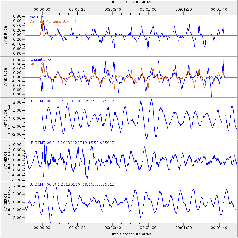
DGMT Dagmar, Montana, USA - Earthquake Result Viewer
*The percent match for this event was below the threshold and hence no stack was calculated.
| Earthquake location: |
Near Coast Of Nicaragua |
| Earthquake latitude/longitude: |
12.6/-87.8 |
| Earthquake time(UTC): |
2013/01/20 (020) 19:10:11 GMT |
| Earthquake Depth: |
89 km |
| Earthquake Magnitude: |
5.5 MD |
| Earthquake Catalog/Contributor: |
NEIC PDE/NEIC PDE-W |
|
| Network: |
US United States National Seismic Network |
| Station: |
DGMT Dagmar, Montana, USA |
| Lat/Lon: |
48.47 N/104.20 W |
| Elevation: |
0.0 m |
|
| Distance: |
38.3 deg |
| Az: |
342.358 deg |
| Baz: |
153.6 deg |
| Ray Param: |
$rayparam |
*The percent match for this event was below the threshold and hence was not used in the summary stack. |
|
| Radial Match: |
47.755135 % |
| Radial Bump: |
286 |
| Transverse Match: |
64.689964 % |
| Transverse Bump: |
395 |
| SOD ConfigId: |
558545 |
| Insert Time: |
2013-09-18 04:33:14.959 +0000 |
| GWidth: |
2.5 |
| Max Bumps: |
400 |
| Tol: |
0.001 |
|
Signal To Noise
| Channel | StoN | STA | LTA |
| US:DGMT:00:BHZ:20130120T19:16:53.02501Z | 1.5144686 | 4.4852666E-7 | 2.9616112E-7 |
| US:DGMT:00:BH1:20130120T19:16:53.02501Z | 2.0053647 | 1.3218244E-6 | 6.591442E-7 |
| US:DGMT:00:BH2:20130120T19:16:53.02501Z | 0.47509685 | 4.7901455E-7 | 1.008246E-6 |
| Arrivals |
| Ps | |
| PpPs | |
| PsPs/PpSs | |


