You are here: Home > Network List > US - United States National Seismic Network Stations List
> Station ERPA Erie, Pennsylvania, USA > Earthquake Result Viewer
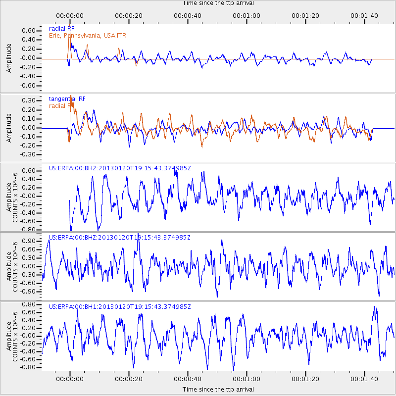
ERPA Erie, Pennsylvania, USA - Earthquake Result Viewer
*The percent match for this event was below the threshold and hence no stack was calculated.
| Earthquake location: |
Near Coast Of Nicaragua |
| Earthquake latitude/longitude: |
12.6/-87.8 |
| Earthquake time(UTC): |
2013/01/20 (020) 19:10:11 GMT |
| Earthquake Depth: |
89 km |
| Earthquake Magnitude: |
5.5 MD |
| Earthquake Catalog/Contributor: |
NEIC PDE/NEIC PDE-W |
|
| Network: |
US United States National Seismic Network |
| Station: |
ERPA Erie, Pennsylvania, USA |
| Lat/Lon: |
42.12 N/79.99 W |
| Elevation: |
306 m |
|
| Distance: |
30.2 deg |
| Az: |
11.578 deg |
| Baz: |
195.271 deg |
| Ray Param: |
$rayparam |
*The percent match for this event was below the threshold and hence was not used in the summary stack. |
|
| Radial Match: |
70.68166 % |
| Radial Bump: |
400 |
| Transverse Match: |
54.702038 % |
| Transverse Bump: |
400 |
| SOD ConfigId: |
558545 |
| Insert Time: |
2013-09-18 04:33:25.178 +0000 |
| GWidth: |
2.5 |
| Max Bumps: |
400 |
| Tol: |
0.001 |
|
Signal To Noise
| Channel | StoN | STA | LTA |
| US:ERPA:00:BHZ:20130120T19:15:43.374985Z | 0.7643937 | 2.9181913E-7 | 3.817655E-7 |
| US:ERPA:00:BH1:20130120T19:15:43.374985Z | 1.5985439 | 3.7367963E-7 | 2.337625E-7 |
| US:ERPA:00:BH2:20130120T19:15:43.374985Z | 0.8390704 | 2.9508888E-7 | 3.516855E-7 |
| Arrivals |
| Ps | |
| PpPs | |
| PsPs/PpSs | |


