You are here: Home > Network List > IU - Global Seismograph Network (GSN - IRIS/USGS) Stations List
> Station PMG Port Moresby, New Guinea > Earthquake Result Viewer
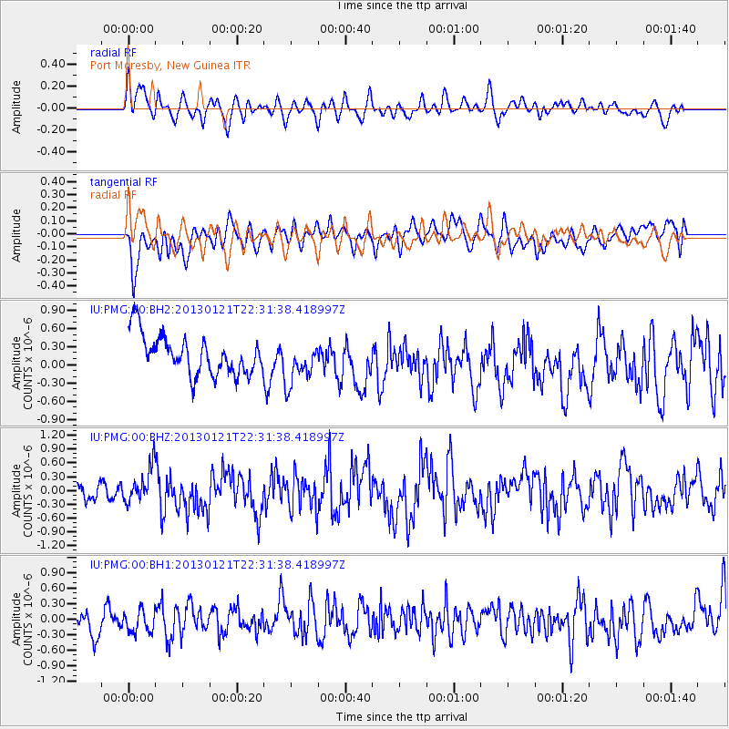
PMG Port Moresby, New Guinea - Earthquake Result Viewer
*The percent match for this event was below the threshold and hence no stack was calculated.
| Earthquake location: |
Northern Sumatra, Indonesia |
| Earthquake latitude/longitude: |
4.9/95.9 |
| Earthquake time(UTC): |
2013/01/21 (021) 22:22:52 GMT |
| Earthquake Depth: |
12 km |
| Earthquake Magnitude: |
5.8 MB, 6.0 MS, 6.1 MW, 6.0 MW |
| Earthquake Catalog/Contributor: |
WHDF/NEIC |
|
| Network: |
IU Global Seismograph Network (GSN - IRIS/USGS) |
| Station: |
PMG Port Moresby, New Guinea |
| Lat/Lon: |
9.40 S/147.16 E |
| Elevation: |
90 m |
|
| Distance: |
53.0 deg |
| Az: |
105.57 deg |
| Baz: |
283.421 deg |
| Ray Param: |
$rayparam |
*The percent match for this event was below the threshold and hence was not used in the summary stack. |
|
| Radial Match: |
56.995556 % |
| Radial Bump: |
400 |
| Transverse Match: |
39.565296 % |
| Transverse Bump: |
400 |
| SOD ConfigId: |
558545 |
| Insert Time: |
2013-09-18 04:42:54.160 +0000 |
| GWidth: |
2.5 |
| Max Bumps: |
400 |
| Tol: |
0.001 |
|
Signal To Noise
| Channel | StoN | STA | LTA |
| IU:PMG:00:BHZ:20130121T22:31:38.418997Z | 1.8784902 | 3.9070463E-7 | 2.0798863E-7 |
| IU:PMG:00:BH1:20130121T22:31:38.418997Z | 0.8069202 | 2.824311E-7 | 3.5001122E-7 |
| IU:PMG:00:BH2:20130121T22:31:38.418997Z | 1.0866649 | 3.5291507E-7 | 3.2476902E-7 |
| Arrivals |
| Ps | |
| PpPs | |
| PsPs/PpSs | |


