You are here: Home > Network List > US - United States National Seismic Network Stations List
> Station WUAZ Wupatki, Arizona, USA > Earthquake Result Viewer
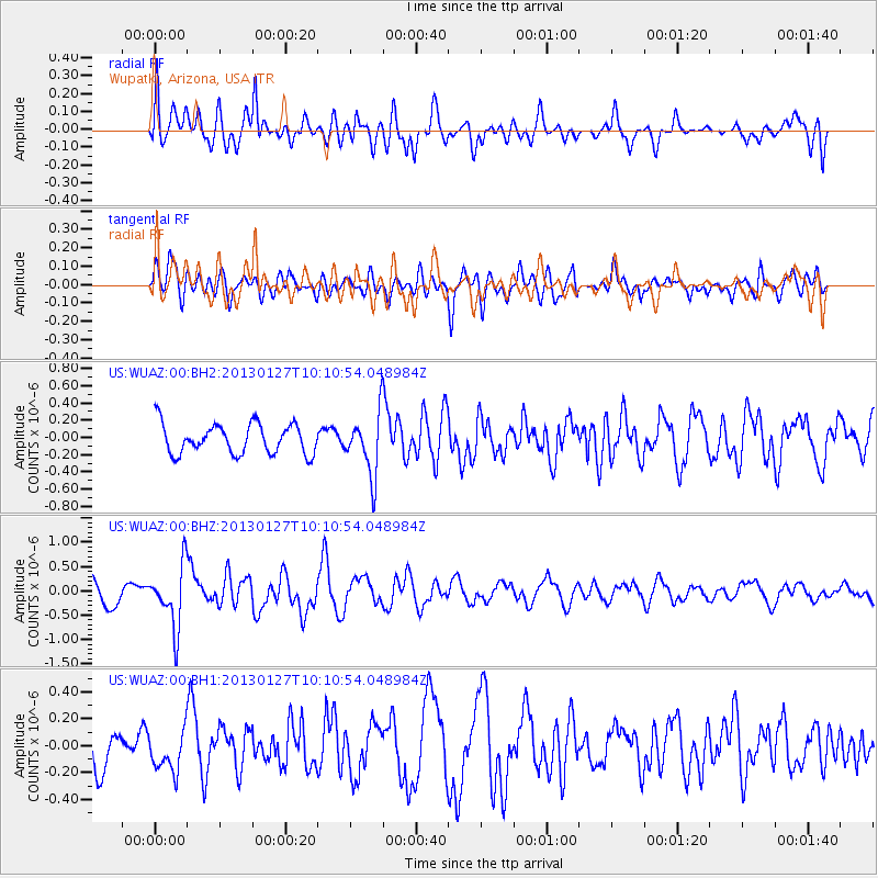
WUAZ Wupatki, Arizona, USA - Earthquake Result Viewer
*The percent match for this event was below the threshold and hence no stack was calculated.
| Earthquake location: |
Tonga Islands |
| Earthquake latitude/longitude: |
-16.1/-173.2 |
| Earthquake time(UTC): |
2013/01/27 (027) 09:59:29 GMT |
| Earthquake Depth: |
19 km |
| Earthquake Magnitude: |
5.7 MB, 5.5 MS, 5.7 MW, 5.7 MW |
| Earthquake Catalog/Contributor: |
WHDF/NEIC |
|
| Network: |
US United States National Seismic Network |
| Station: |
WUAZ Wupatki, Arizona, USA |
| Lat/Lon: |
35.52 N/111.37 W |
| Elevation: |
1592 m |
|
| Distance: |
77.9 deg |
| Az: |
47.376 deg |
| Baz: |
240.108 deg |
| Ray Param: |
$rayparam |
*The percent match for this event was below the threshold and hence was not used in the summary stack. |
|
| Radial Match: |
63.19561 % |
| Radial Bump: |
400 |
| Transverse Match: |
62.426533 % |
| Transverse Bump: |
400 |
| SOD ConfigId: |
558545 |
| Insert Time: |
2013-09-18 04:53:21.365 +0000 |
| GWidth: |
2.5 |
| Max Bumps: |
400 |
| Tol: |
0.001 |
|
Signal To Noise
| Channel | StoN | STA | LTA |
| US:WUAZ:00:BHZ:20130127T10:10:54.048984Z | 2.627154 | 6.2661417E-7 | 2.3851442E-7 |
| US:WUAZ:00:BH1:20130127T10:10:54.048984Z | 1.0393353 | 1.5194027E-7 | 1.4618986E-7 |
| US:WUAZ:00:BH2:20130127T10:10:54.048984Z | 2.0468047 | 3.5190715E-7 | 1.7193001E-7 |
| Arrivals |
| Ps | |
| PpPs | |
| PsPs/PpSs | |


