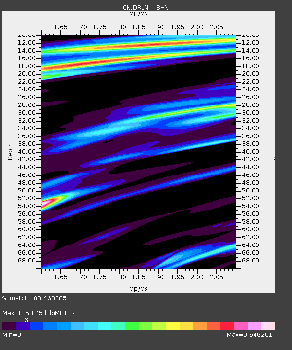
DRLN Deer Lake, NFLD. - Earthquake Result Viewer

Earthquake location: Vancouver Island, Canada Region
Earthquake latitude/longitude: 49.3/-128.8
Earthquake time(UTC): 2004/11/02 (307) 10:02:12 GMT
Earthquake Depth: 10 km
Earthquake Magnitude: 5.8 MB, 6.4 MS, 6.7 MW, 6.6 MW
Earthquake Catalog/Contributor: WHDF/NEIC
Network: CN Canadian National Seismograph Network
Station: DRLN Deer Lake, NFLD.
Lat/Lon: 49.26 N/57.50 W
Elevation: 238 m
Distance: 44.9 deg
Az: 61.582 deg
Baz: 298.463 deg
Ray Param: 0.071650416
Estimated Moho Depth: 53.25 km
Estimated Crust Vp/Vs: 1.60
Assumed Crust Vp: 6.35 km/s
Estimated Crust Vs: 3.969 km/s
Estimated Crust Poisson's Ratio: 0.18
Radial Match: 83.468285 %
Radial Bump: 311
Transverse Match: 40.339554 %
Transverse Bump: 328
SOD ConfigId: 2459
Insert Time: 2010-02-27 05:34:08.647 +0000
GWidth: 2.5
Max Bumps: 400
Tol: 0.001

Signal To Noise

ChannelStoNSTALTA
CN:DRLN: :BHN:20041102T10:09:56.348992Z1.838854911730.8526379.433
CN:DRLN: :BHE:20041102T10:09:56.348992Z3.10388029678.9953118.3533
CN:DRLN: :BHZ:20041102T10:09:56.348992Z3.227376231588.5359787.683
Arrivals
Ps5.4 SECOND
PpPs20 SECOND
PsPs/PpSs26 SECOND