You are here: Home > Network List > IU - Global Seismograph Network (GSN - IRIS/USGS) Stations List
> Station MBWA Marble Bar, Western Australia > Earthquake Result Viewer
MBWA Marble Bar, Western Australia - Earthquake Result Viewer
| Earthquake location: |
Santa Cruz Islands |
| Earthquake latitude/longitude: |
-10.9/165.2 |
| Earthquake time(UTC): |
2013/02/06 (037) 00:07:22 GMT |
| Earthquake Depth: |
11 km |
| Earthquake Magnitude: |
5.6 MB, 6.1 MS, 6.0 MW, 6.0 MW |
| Earthquake Catalog/Contributor: |
WHDF/NEIC |
|
| Network: |
IU Global Seismograph Network (GSN - IRIS/USGS) |
| Station: |
MBWA Marble Bar, Western Australia |
| Lat/Lon: |
21.16 S/119.73 E |
| Elevation: |
190 m |
|
| Distance: |
44.8 deg |
| Az: |
250.944 deg |
| Baz: |
84.117 deg |
| Ray Param: |
0.07169566 |
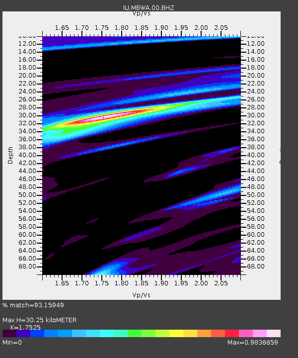
| Estimated Moho Depth: |
30.25 km |
| Estimated Crust Vp/Vs: |
1.75 |
| Assumed Crust Vp: |
6.464 km/s |
| Estimated Crust Vs: |
3.688 km/s |
| Estimated Crust Poisson's Ratio: |
0.26 |
|
| Radial Match: |
93.15949 % |
| Radial Bump: |
307 |
| Transverse Match: |
84.715996 % |
| Transverse Bump: |
400 |
| SOD ConfigId: |
558545 |
| Insert Time: |
2013-09-18 05:01:42.253 +0000 |
| GWidth: |
2.5 |
| Max Bumps: |
400 |
| Tol: |
0.001 |
|

Signal To Noise
| Channel | StoN | STA | LTA |
| IU:MBWA:00:BHZ:20130206T00:15:04.869012Z | 5.19401 | 8.886467E-7 | 1.7109069E-7 |
| IU:MBWA:00:BH1:20130206T00:15:04.869012Z | 3.1937616 | 4.329172E-7 | 1.3555088E-7 |
| IU:MBWA:00:BH2:20130206T00:15:04.869012Z | 3.9679778 | 5.6593365E-7 | 1.426252E-7 |
| Arrivals |
| Ps | 3.8 SECOND |
| PpPs | 12 SECOND |
| PsPs/PpSs | 16 SECOND |


