You are here: Home > Network List > II - Global Seismograph Network (GSN - IRIS/IDA) Stations List
> Station WRAB Tennant Creek, NT, Australia > Earthquake Result Viewer
WRAB Tennant Creek, NT, Australia - Earthquake Result Viewer
| Earthquake location: |
Santa Cruz Islands |
| Earthquake latitude/longitude: |
-10.8/165.1 |
| Earthquake time(UTC): |
2013/02/06 (037) 01:12:25 GMT |
| Earthquake Depth: |
24 km |
| Earthquake Magnitude: |
6.4 MB, 7.4 MS, 8.0 MW, 7.9 MW |
| Earthquake Catalog/Contributor: |
WHDF/NEIC |
|
| Network: |
II Global Seismograph Network (GSN - IRIS/IDA) |
| Station: |
WRAB Tennant Creek, NT, Australia |
| Lat/Lon: |
19.93 S/134.36 E |
| Elevation: |
366 m |
|
| Distance: |
31.0 deg |
| Az: |
249.228 deg |
| Baz: |
77.539 deg |
| Ray Param: |
0.07917525 |
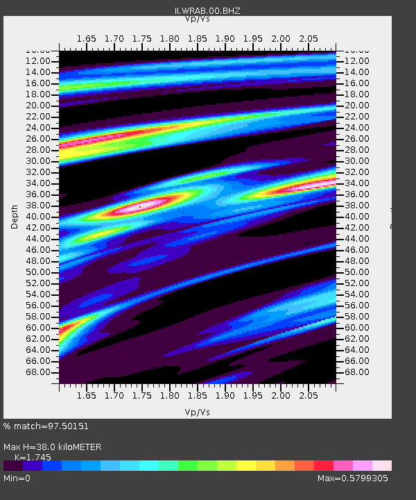
| Estimated Moho Depth: |
38.0 km |
| Estimated Crust Vp/Vs: |
1.75 |
| Assumed Crust Vp: |
6.642 km/s |
| Estimated Crust Vs: |
3.806 km/s |
| Estimated Crust Poisson's Ratio: |
0.26 |
|
| Radial Match: |
97.50151 % |
| Radial Bump: |
337 |
| Transverse Match: |
87.996124 % |
| Transverse Bump: |
400 |
| SOD ConfigId: |
558545 |
| Insert Time: |
2013-09-18 05:04:10.944 +0000 |
| GWidth: |
2.5 |
| Max Bumps: |
400 |
| Tol: |
0.001 |
|

Signal To Noise
| Channel | StoN | STA | LTA |
| II:WRAB:00:BHZ:20130206T01:18:10.518995Z | 2.83092 | 7.839811E-6 | 2.7693509E-6 |
| II:WRAB:00:BH1:20130206T01:18:10.518995Z | 1.8617194 | 1.8993768E-6 | 1.0202272E-6 |
| II:WRAB:00:BH2:20130206T01:18:10.518995Z | 4.734313 | 6.282977E-6 | 1.3271149E-6 |
| Arrivals |
| Ps | 4.7 SECOND |
| PpPs | 14 SECOND |
| PsPs/PpSs | 19 SECOND |


