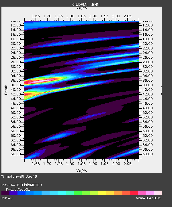
DRLN Deer Lake, NFLD. - Earthquake Result Viewer
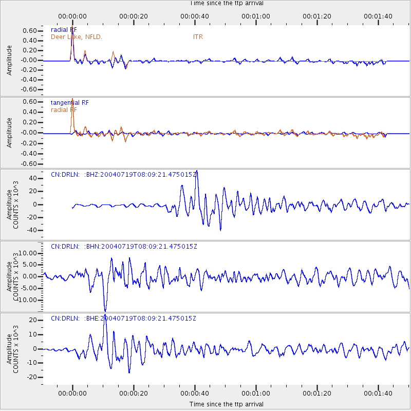
Earthquake location: Vancouver Island, Canada Region
Earthquake latitude/longitude: 49.6/-127.0
Earthquake time(UTC): 2004/07/19 (201) 08:01:49 GMT
Earthquake Depth: 24 km
Earthquake Magnitude: 5.9 MB, 6.2 MS, 6.4 MW, 6.4 MW
Earthquake Catalog/Contributor: WHDF/NEIC
Network: CN Canadian National Seismograph Network
Station: DRLN Deer Lake, NFLD.
Lat/Lon: 49.26 N/57.50 W
Elevation: 238 m
Distance: 43.7 deg
Az: 62.699 deg
Baz: 298.113 deg
Ray Param: 0.072364815
Estimated Moho Depth: 36.0 km
Estimated Crust Vp/Vs: 1.68
Assumed Crust Vp: 6.35 km/s
Estimated Crust Vs: 3.791 km/s
Estimated Crust Poisson's Ratio: 0.22
Radial Match: 89.65646 %
Radial Bump: 314
Transverse Match: 69.915344 %
Transverse Bump: 400
SOD ConfigId: 2459
Insert Time: 2010-02-27 05:34:24.058 +0000
GWidth: 2.5
Max Bumps: 400
Tol: 0.001

Signal To Noise

ChannelStoNSTALTA
CN:DRLN: :BHN:20040719T08:09:21.475015Z1.79316191575.4458878.58545
CN:DRLN: :BHE:20040719T08:09:21.475015Z3.63499783038.51835.9042
CN:DRLN: :BHZ:20040719T08:09:21.475015Z4.74847277173.91510.7805
Arrivals
Ps4.1 SECOND
PpPs14 SECOND
PsPs/PpSs18 SECOND