You are here: Home > Network List > IU - Global Seismograph Network (GSN - IRIS/USGS) Stations List
> Station JOHN Johnston Island, USA > Earthquake Result Viewer
JOHN Johnston Island, USA - Earthquake Result Viewer

| Earthquake location: |
Santa Cruz Islands |
| Earthquake latitude/longitude: |
-10.8/165.1 |
| Earthquake time(UTC): |
2013/02/06 (037) 01:12:25 GMT |
| Earthquake Depth: |
24 km |
| Earthquake Magnitude: |
6.4 MB, 7.4 MS, 8.0 MW, 7.9 MW |
| Earthquake Catalog/Contributor: |
WHDF/NEIC |
|
| Network: |
IU Global Seismograph Network (GSN - IRIS/USGS) |
| Station: |
JOHN Johnston Island, USA |
| Lat/Lon: |
16.73 N/169.53 W |
| Elevation: |
2.0 m |
|
| Distance: |
37.1 deg |
| Az: |
42.852 deg |
| Baz: |
224.217 deg |
| Ray Param: |
0.076278694 |
| Estimated Moho Depth: |
66.25 km |
| Estimated Crust Vp/Vs: |
2.10 |
| Assumed Crust Vp: |
4.24 km/s |
| Estimated Crust Vs: |
2.021 km/s |
| Estimated Crust Poisson's Ratio: |
0.35 |
|
| Radial Match: |
87.827576 % |
| Radial Bump: |
400 |
| Transverse Match: |
65.492775 % |
| Transverse Bump: |
400 |
| SOD ConfigId: |
558545 |
| Insert Time: |
2013-09-18 05:04:44.037 +0000 |
| GWidth: |
2.5 |
| Max Bumps: |
400 |
| Tol: |
0.001 |
|
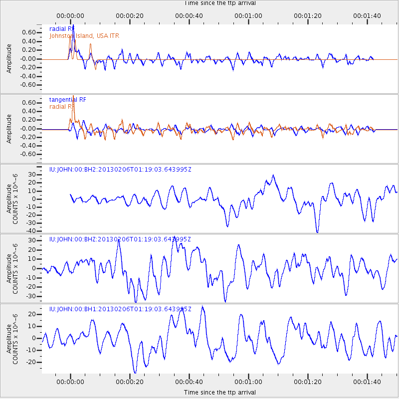
Signal To Noise
| Channel | StoN | STA | LTA |
| IU:JOHN:00:BHZ:20130206T01:19:03.643995Z | 1.6503533 | 6.225242E-6 | 3.772066E-6 |
| IU:JOHN:00:BH1:20130206T01:19:03.643995Z | 0.9454385 | 3.3959886E-6 | 3.591972E-6 |
| IU:JOHN:00:BH2:20130206T01:19:03.643995Z | 3.1742027 | 1.0639793E-5 | 3.3519575E-6 |
| Arrivals |
| Ps | 18 SECOND |
| PpPs | 47 SECOND |
| PsPs/PpSs | 65 SECOND |


