You are here: Home > Network List > IU - Global Seismograph Network (GSN - IRIS/USGS) Stations List
> Station NWAO Narrogin, Australia > Earthquake Result Viewer
NWAO Narrogin, Australia - Earthquake Result Viewer
| Earthquake location: |
Santa Cruz Islands |
| Earthquake latitude/longitude: |
-10.8/165.1 |
| Earthquake time(UTC): |
2013/02/06 (037) 01:12:25 GMT |
| Earthquake Depth: |
24 km |
| Earthquake Magnitude: |
6.4 MB, 7.4 MS, 8.0 MW, 7.9 MW |
| Earthquake Catalog/Contributor: |
WHDF/NEIC |
|
| Network: |
IU Global Seismograph Network (GSN - IRIS/USGS) |
| Station: |
NWAO Narrogin, Australia |
| Lat/Lon: |
32.93 S/117.24 E |
| Elevation: |
380 m |
|
| Distance: |
49.1 deg |
| Az: |
235.635 deg |
| Baz: |
74.654 deg |
| Ray Param: |
0.06889221 |
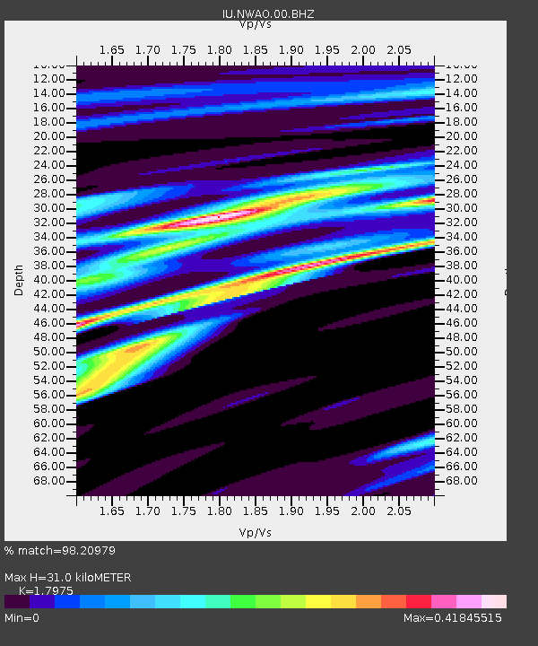
| Estimated Moho Depth: |
31.0 km |
| Estimated Crust Vp/Vs: |
1.80 |
| Assumed Crust Vp: |
6.419 km/s |
| Estimated Crust Vs: |
3.571 km/s |
| Estimated Crust Poisson's Ratio: |
0.28 |
|
| Radial Match: |
98.20979 % |
| Radial Bump: |
209 |
| Transverse Match: |
87.032326 % |
| Transverse Bump: |
385 |
| SOD ConfigId: |
558545 |
| Insert Time: |
2013-09-18 05:05:01.039 +0000 |
| GWidth: |
2.5 |
| Max Bumps: |
400 |
| Tol: |
0.001 |
|
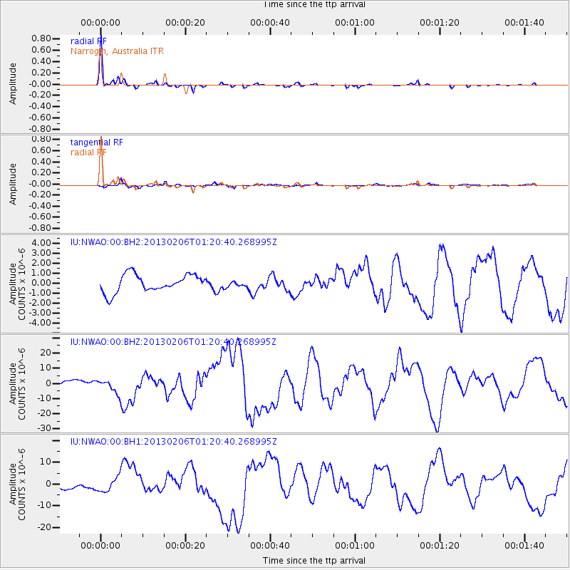
Signal To Noise
| Channel | StoN | STA | LTA |
| IU:NWAO:00:BHZ:20130206T01:20:40.268995Z | 3.3422093 | 4.9625974E-6 | 1.4848255E-6 |
| IU:NWAO:00:BH1:20130206T01:20:40.268995Z | 3.436336 | 3.4572947E-6 | 1.0060992E-6 |
| IU:NWAO:00:BH2:20130206T01:20:40.268995Z | 0.37316966 | 3.29347E-7 | 8.825663E-7 |
| Arrivals |
| Ps | 4.1 SECOND |
| PpPs | 13 SECOND |
| PsPs/PpSs | 17 SECOND |


