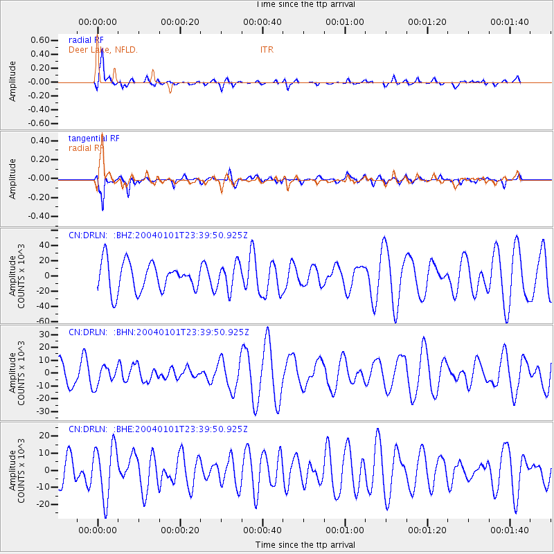
DRLN Deer Lake, NFLD. - Earthquake Result Viewer
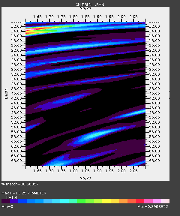
Earthquake location: Near Coast Of Guerrero, Mexico
Earthquake latitude/longitude: 17.5/-101.3
Earthquake time(UTC): 2004/01/01 (001) 23:31:50 GMT
Earthquake Depth: 29 km
Earthquake Magnitude: 5.6 MB, 5.7 MS, 6.0 MW, 6.0 MW
Earthquake Catalog/Contributor: WHDF/NEIC
Network: CN Canadian National Seismograph Network
Station: DRLN Deer Lake, NFLD.
Lat/Lon: 49.26 N/57.50 W
Elevation: 238 m
Distance: 47.4 deg
Az: 38.033 deg
Baz: 243.823 deg
Ray Param: 0.069963396
Estimated Moho Depth: 13.25 km
Estimated Crust Vp/Vs: 1.60
Assumed Crust Vp: 6.35 km/s
Estimated Crust Vs: 3.969 km/s
Estimated Crust Poisson's Ratio: 0.18
Radial Match: 80.56057 %
Radial Bump: 400
Transverse Match: 74.763626 %
Transverse Bump: 400
SOD ConfigId: 7314
Insert Time: 2010-02-27 05:34:33.626 +0000
GWidth: 2.5
Max Bumps: 400
Tol: 0.001

Signal To Noise

ChannelStoNSTALTA
CN:DRLN: :BHN:20040101T23:39:50.925Z0.50224757015.60113968.413
CN:DRLN: :BHE:20040101T23:39:50.925Z2.079240815765.9097582.5317
CN:DRLN: :BHZ:20040101T23:39:50.925Z0.9101347317116.73818806.818
Arrivals
Ps1.3 SECOND
PpPs5.1 SECOND
PsPs/PpSs6.4 SECOND