You are here: Home > Network List > IU - Global Seismograph Network (GSN - IRIS/USGS) Stations List
> Station JOHN Johnston Island, USA > Earthquake Result Viewer
JOHN Johnston Island, USA - Earthquake Result Viewer
| Earthquake location: |
Santa Cruz Islands |
| Earthquake latitude/longitude: |
-11.3/165.9 |
| Earthquake time(UTC): |
2013/02/06 (037) 01:22:12 GMT |
| Earthquake Depth: |
13 km |
| Earthquake Magnitude: |
5.6 MB |
| Earthquake Catalog/Contributor: |
WHDF/NEIC |
|
| Network: |
IU Global Seismograph Network (GSN - IRIS/USGS) |
| Station: |
JOHN Johnston Island, USA |
| Lat/Lon: |
16.73 N/169.53 W |
| Elevation: |
2.0 m |
|
| Distance: |
37.0 deg |
| Az: |
41.471 deg |
| Baz: |
222.674 deg |
| Ray Param: |
0.07637307 |
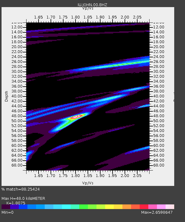
| Estimated Moho Depth: |
48.0 km |
| Estimated Crust Vp/Vs: |
1.81 |
| Assumed Crust Vp: |
4.24 km/s |
| Estimated Crust Vs: |
2.346 km/s |
| Estimated Crust Poisson's Ratio: |
0.28 |
|
| Radial Match: |
88.25424 % |
| Radial Bump: |
400 |
| Transverse Match: |
65.366165 % |
| Transverse Bump: |
400 |
| SOD ConfigId: |
558545 |
| Insert Time: |
2013-09-18 05:09:55.506 +0000 |
| GWidth: |
2.5 |
| Max Bumps: |
400 |
| Tol: |
0.001 |
|
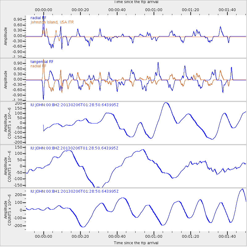
Signal To Noise
| Channel | StoN | STA | LTA |
| IU:JOHN:00:BHZ:20130206T01:28:50.643995Z | 1.0240244 | 3.7508587E-5 | 3.6628608E-5 |
| IU:JOHN:00:BH1:20130206T01:28:50.643995Z | 0.45472592 | 2.8504832E-5 | 6.268574E-5 |
| IU:JOHN:00:BH2:20130206T01:28:50.643995Z | 2.350991 | 6.97549E-5 | 2.9670422E-5 |
| Arrivals |
| Ps | 9.4 SECOND |
| PpPs | 31 SECOND |
| PsPs/PpSs | 40 SECOND |


