You are here: Home > Network List > US - United States National Seismic Network Stations List
> Station WUAZ Wupatki, Arizona, USA > Earthquake Result Viewer
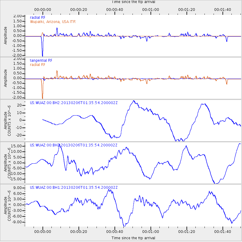
WUAZ Wupatki, Arizona, USA - Earthquake Result Viewer
*The percent match for this event was below the threshold and hence no stack was calculated.
| Earthquake location: |
Santa Cruz Islands Region |
| Earthquake latitude/longitude: |
-11.2/164.9 |
| Earthquake time(UTC): |
2013/02/06 (037) 01:23:19 GMT |
| Earthquake Depth: |
10 km |
| Earthquake Magnitude: |
6.6 MB, 7.1 MW, 7.1 MW |
| Earthquake Catalog/Contributor: |
WHDF/NEIC |
|
| Network: |
US United States National Seismic Network |
| Station: |
WUAZ Wupatki, Arizona, USA |
| Lat/Lon: |
35.52 N/111.37 W |
| Elevation: |
1592 m |
|
| Distance: |
91.4 deg |
| Az: |
54.21 deg |
| Baz: |
257.344 deg |
| Ray Param: |
$rayparam |
*The percent match for this event was below the threshold and hence was not used in the summary stack. |
|
| Radial Match: |
75.23406 % |
| Radial Bump: |
336 |
| Transverse Match: |
42.988766 % |
| Transverse Bump: |
400 |
| SOD ConfigId: |
558545 |
| Insert Time: |
2013-09-18 05:14:24.354 +0000 |
| GWidth: |
2.5 |
| Max Bumps: |
400 |
| Tol: |
0.001 |
|
Signal To Noise
| Channel | StoN | STA | LTA |
| US:WUAZ:00:BHZ:20130206T01:35:54.200002Z | 2.1166635 | 3.1899426E-6 | 1.5070618E-6 |
| US:WUAZ:00:BH1:20130206T01:35:54.200002Z | 1.8647943 | 1.8543907E-6 | 9.94421E-7 |
| US:WUAZ:00:BH2:20130206T01:35:54.200002Z | 1.864658 | 7.76535E-6 | 4.1644903E-6 |
| Arrivals |
| Ps | |
| PpPs | |
| PsPs/PpSs | |


