You are here: Home > Network List > US - United States National Seismic Network Stations List
> Station MSO Missoula, Montana, USA > Earthquake Result Viewer
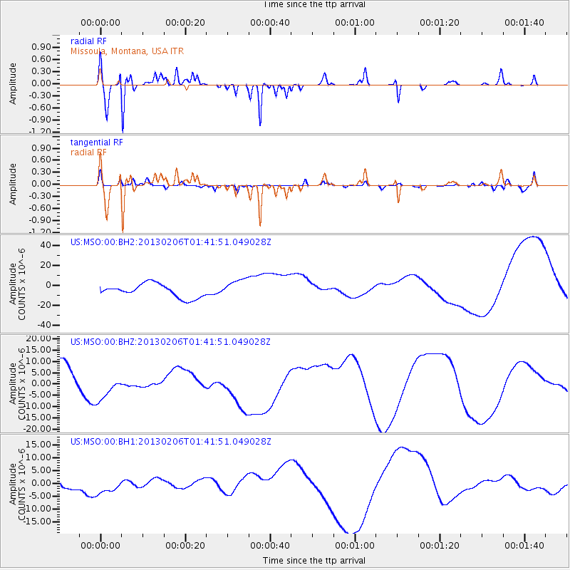
MSO Missoula, Montana, USA - Earthquake Result Viewer
*The percent match for this event was below the threshold and hence no stack was calculated.
| Earthquake location: |
Santa Cruz Islands Region |
| Earthquake latitude/longitude: |
-10.8/164.6 |
| Earthquake time(UTC): |
2013/02/06 (037) 01:29:13 GMT |
| Earthquake Depth: |
10 km |
| Earthquake Magnitude: |
5.5 MB |
| Earthquake Catalog/Contributor: |
WHDF/NEIC |
|
| Network: |
US United States National Seismic Network |
| Station: |
MSO Missoula, Montana, USA |
| Lat/Lon: |
46.83 N/113.94 W |
| Elevation: |
1264 m |
|
| Distance: |
92.0 deg |
| Az: |
42.793 deg |
| Baz: |
256.467 deg |
| Ray Param: |
$rayparam |
*The percent match for this event was below the threshold and hence was not used in the summary stack. |
|
| Radial Match: |
87.57146 % |
| Radial Bump: |
313 |
| Transverse Match: |
58.5704 % |
| Transverse Bump: |
400 |
| SOD ConfigId: |
558545 |
| Insert Time: |
2013-09-18 05:16:50.526 +0000 |
| GWidth: |
2.5 |
| Max Bumps: |
400 |
| Tol: |
0.001 |
|
Signal To Noise
| Channel | StoN | STA | LTA |
| US:MSO:00:BHZ:20130206T01:41:51.049028Z | 0.7948397 | 5.6495714E-6 | 7.107813E-6 |
| US:MSO:00:BH1:20130206T01:41:51.049028Z | 1.1272303 | 3.063547E-6 | 2.7177648E-6 |
| US:MSO:00:BH2:20130206T01:41:51.049028Z | 1.4609244 | 9.753596E-6 | 6.676318E-6 |
| Arrivals |
| Ps | |
| PpPs | |
| PsPs/PpSs | |


