You are here: Home > Network List > US - United States National Seismic Network Stations List
> Station MSO Missoula, Montana, USA > Earthquake Result Viewer
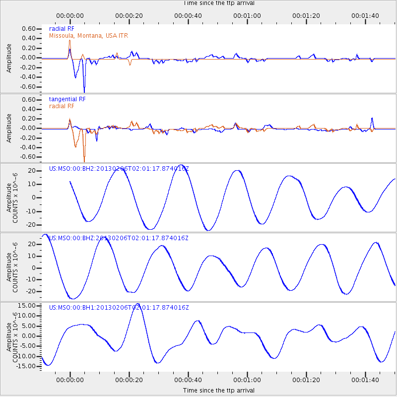
MSO Missoula, Montana, USA - Earthquake Result Viewer
*The percent match for this event was below the threshold and hence no stack was calculated.
| Earthquake location: |
Santa Cruz Islands |
| Earthquake latitude/longitude: |
-11.6/166.0 |
| Earthquake time(UTC): |
2013/02/06 (037) 01:48:42 GMT |
| Earthquake Depth: |
10 km |
| Earthquake Magnitude: |
5.5 MB |
| Earthquake Catalog/Contributor: |
WHDF/NEIC |
|
| Network: |
US United States National Seismic Network |
| Station: |
MSO Missoula, Montana, USA |
| Lat/Lon: |
46.83 N/113.94 W |
| Elevation: |
1264 m |
|
| Distance: |
91.7 deg |
| Az: |
42.576 deg |
| Baz: |
254.88 deg |
| Ray Param: |
$rayparam |
*The percent match for this event was below the threshold and hence was not used in the summary stack. |
|
| Radial Match: |
96.23634 % |
| Radial Bump: |
400 |
| Transverse Match: |
68.55042 % |
| Transverse Bump: |
400 |
| SOD ConfigId: |
558545 |
| Insert Time: |
2013-09-18 05:26:28.158 +0000 |
| GWidth: |
2.5 |
| Max Bumps: |
400 |
| Tol: |
0.001 |
|
Signal To Noise
| Channel | StoN | STA | LTA |
| US:MSO:00:BHZ:20130206T02:01:17.874016Z | 1.5932717 | 2.831457E-5 | 1.7771337E-5 |
| US:MSO:00:BH1:20130206T02:01:17.874016Z | 0.9215215 | 6.995523E-6 | 7.591275E-6 |
| US:MSO:00:BH2:20130206T02:01:17.874016Z | 0.94153583 | 1.2615797E-5 | 1.3399168E-5 |
| Arrivals |
| Ps | |
| PpPs | |
| PsPs/PpSs | |


