You are here: Home > Network List > US - United States National Seismic Network Stations List
> Station MVCO Mesa Verde, Colorado, USA > Earthquake Result Viewer
MVCO Mesa Verde, Colorado, USA - Earthquake Result Viewer
| Earthquake location: |
Santa Cruz Islands |
| Earthquake latitude/longitude: |
-10.5/165.6 |
| Earthquake time(UTC): |
2013/02/06 (037) 01:54:14 GMT |
| Earthquake Depth: |
8.8 km |
| Earthquake Magnitude: |
6.5 MB, 7.0 MW, 7.0 MW |
| Earthquake Catalog/Contributor: |
WHDF/NEIC |
|
| Network: |
US United States National Seismic Network |
| Station: |
MVCO Mesa Verde, Colorado, USA |
| Lat/Lon: |
37.21 N/108.50 W |
| Elevation: |
2170 m |
|
| Distance: |
93.0 deg |
| Az: |
52.889 deg |
| Baz: |
259.222 deg |
| Ray Param: |
0.04133965 |
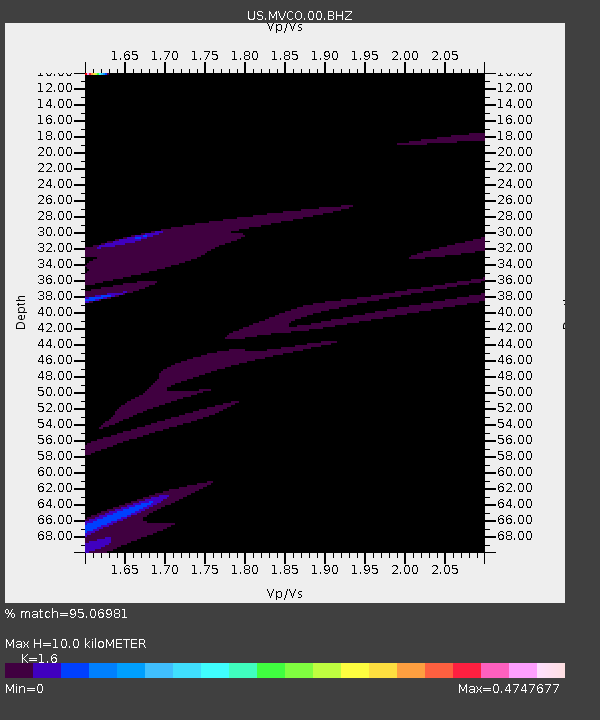
| Estimated Moho Depth: |
10.0 km |
| Estimated Crust Vp/Vs: |
1.60 |
| Assumed Crust Vp: |
6.476 km/s |
| Estimated Crust Vs: |
4.047 km/s |
| Estimated Crust Poisson's Ratio: |
0.18 |
|
| Radial Match: |
95.06981 % |
| Radial Bump: |
396 |
| Transverse Match: |
81.73891 % |
| Transverse Bump: |
400 |
| SOD ConfigId: |
558545 |
| Insert Time: |
2013-09-18 05:28:36.891 +0000 |
| GWidth: |
2.5 |
| Max Bumps: |
400 |
| Tol: |
0.001 |
|
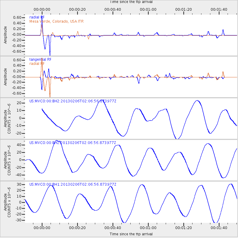
Signal To Noise
| Channel | StoN | STA | LTA |
| US:MVCO:00:BHZ:20130206T02:06:56.873977Z | 1.7061766 | 2.7991367E-5 | 1.6405904E-5 |
| US:MVCO:00:BH1:20130206T02:06:56.873977Z | 0.9988542 | 1.9216834E-5 | 1.9238876E-5 |
| US:MVCO:00:BH2:20130206T02:06:56.873977Z | 2.985165 | 2.298166E-5 | 7.6986225E-6 |
| Arrivals |
| Ps | 0.9 SECOND |
| PpPs | 3.9 SECOND |
| PsPs/PpSs | 4.9 SECOND |


