You are here: Home > Network List > CN - Canadian National Seismograph Network Stations List
> Station DRLN Deer Lake, NFLD. > Earthquake Result Viewer
DRLN Deer Lake, NFLD. - Earthquake Result Viewer
| Earthquake location: |
Kuril Islands |
| Earthquake latitude/longitude: |
45.2/148.6 |
| Earthquake time(UTC): |
1996/02/22 (053) 14:59:09 GMT |
| Earthquake Depth: |
133 km |
| Earthquake Magnitude: |
6.2 MB, 6.3 UNKNOWN, 6.3 MW |
| Earthquake Catalog/Contributor: |
WHDF/NEIC |
|
| Network: |
CN Canadian National Seismograph Network |
| Station: |
DRLN Deer Lake, NFLD. |
| Lat/Lon: |
49.26 N/57.50 W |
| Elevation: |
238 m |
|
| Distance: |
83.2 deg |
| Az: |
16.851 deg |
| Baz: |
341.774 deg |
| Ray Param: |
0.04604593 |
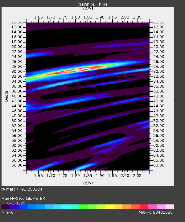
| Estimated Moho Depth: |
29.0 km |
| Estimated Crust Vp/Vs: |
1.81 |
| Assumed Crust Vp: |
6.35 km/s |
| Estimated Crust Vs: |
3.503 km/s |
| Estimated Crust Poisson's Ratio: |
0.28 |
|
| Radial Match: |
91.258224 % |
| Radial Bump: |
400 |
| Transverse Match: |
84.702354 % |
| Transverse Bump: |
400 |
| SOD ConfigId: |
6273 |
| Insert Time: |
2010-02-27 05:35:31.085 +0000 |
| GWidth: |
2.5 |
| Max Bumps: |
400 |
| Tol: |
0.001 |
|

Signal To Noise
| Channel | StoN | STA | LTA |
| CN:DRLN: :BHN:19960222T15:10:50.025012Z | 7.212765 | 5295.14 | 734.1345 |
| CN:DRLN: :BHE:19960222T15:10:50.025012Z | 1.7622745 | 1619.2019 | 918.81366 |
| CN:DRLN: :BHZ:19960222T15:10:50.025012Z | 16.568495 | 18279.84 | 1103.2891 |
| Arrivals |
| Ps | 3.8 SECOND |
| PpPs | 13 SECOND |
| PsPs/PpSs | 16 SECOND |


