You are here: Home > Network List > US - United States National Seismic Network Stations List
> Station MSO Missoula, Montana, USA > Earthquake Result Viewer
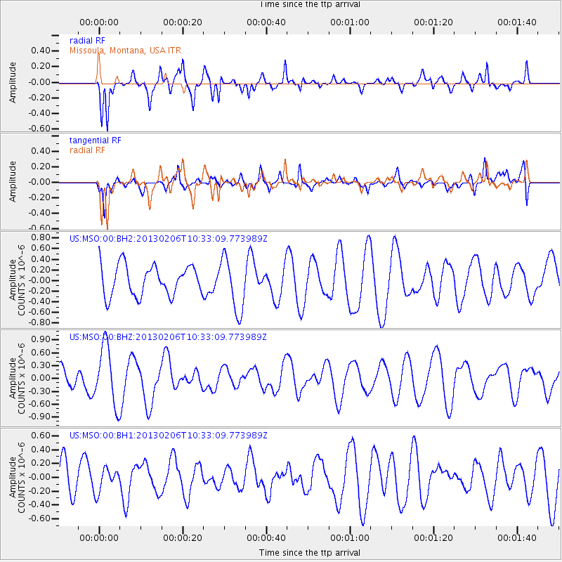
MSO Missoula, Montana, USA - Earthquake Result Viewer
*The percent match for this event was below the threshold and hence no stack was calculated.
| Earthquake location: |
Santa Cruz Islands |
| Earthquake latitude/longitude: |
-10.9/165.3 |
| Earthquake time(UTC): |
2013/02/06 (037) 10:20:34 GMT |
| Earthquake Depth: |
10 km |
| Earthquake Magnitude: |
5.5 MB, 5.9 MS, 5.9 MW, 5.9 MW |
| Earthquake Catalog/Contributor: |
WHDF/NEIC |
|
| Network: |
US United States National Seismic Network |
| Station: |
MSO Missoula, Montana, USA |
| Lat/Lon: |
46.83 N/113.94 W |
| Elevation: |
1264 m |
|
| Distance: |
91.6 deg |
| Az: |
42.69 deg |
| Baz: |
255.946 deg |
| Ray Param: |
$rayparam |
*The percent match for this event was below the threshold and hence was not used in the summary stack. |
|
| Radial Match: |
86.511894 % |
| Radial Bump: |
400 |
| Transverse Match: |
61.31421 % |
| Transverse Bump: |
400 |
| SOD ConfigId: |
558545 |
| Insert Time: |
2013-09-18 05:48:34.324 +0000 |
| GWidth: |
2.5 |
| Max Bumps: |
400 |
| Tol: |
0.001 |
|
Signal To Noise
| Channel | StoN | STA | LTA |
| US:MSO:00:BHZ:20130206T10:33:09.773989Z | 2.5614777 | 7.017762E-7 | 2.739732E-7 |
| US:MSO:00:BH1:20130206T10:33:09.773989Z | 0.56465185 | 1.6935897E-7 | 2.999352E-7 |
| US:MSO:00:BH2:20130206T10:33:09.773989Z | 1.8686348 | 5.236388E-7 | 2.8022532E-7 |
| Arrivals |
| Ps | |
| PpPs | |
| PsPs/PpSs | |


