You are here: Home > Network List > US - United States National Seismic Network Stations List
> Station AMTX Amarillo, Texas, USA > Earthquake Result Viewer
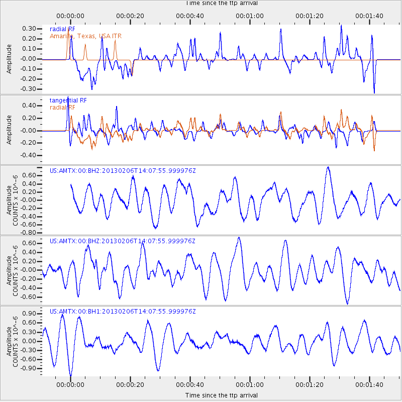
AMTX Amarillo, Texas, USA - Earthquake Result Viewer
*The percent match for this event was below the threshold and hence no stack was calculated.
| Earthquake location: |
Santa Cruz Islands |
| Earthquake latitude/longitude: |
-10.8/166.5 |
| Earthquake time(UTC): |
2013/02/06 (037) 13:54:54 GMT |
| Earthquake Depth: |
14 km |
| Earthquake Magnitude: |
6.0 MB, 5.7 MS, 5.8 MW, 5.8 MW |
| Earthquake Catalog/Contributor: |
WHDF/NEIC |
|
| Network: |
US United States National Seismic Network |
| Station: |
AMTX Amarillo, Texas, USA |
| Lat/Lon: |
34.53 N/101.41 W |
| Elevation: |
1010 m |
|
| Distance: |
97.7 deg |
| Az: |
56.368 deg |
| Baz: |
262.238 deg |
| Ray Param: |
$rayparam |
*The percent match for this event was below the threshold and hence was not used in the summary stack. |
|
| Radial Match: |
55.38081 % |
| Radial Bump: |
400 |
| Transverse Match: |
64.16813 % |
| Transverse Bump: |
355 |
| SOD ConfigId: |
558545 |
| Insert Time: |
2013-09-18 06:01:06.586 +0000 |
| GWidth: |
2.5 |
| Max Bumps: |
400 |
| Tol: |
0.001 |
|
Signal To Noise
| Channel | StoN | STA | LTA |
| US:AMTX:00:BHZ:20130206T14:07:55.999976Z | 0.86159325 | 2.682812E-7 | 3.1137805E-7 |
| US:AMTX:00:BH1:20130206T14:07:55.999976Z | 1.8316361 | 6.663981E-7 | 3.638267E-7 |
| US:AMTX:00:BH2:20130206T14:07:55.999976Z | 0.9583685 | 2.2968005E-7 | 2.3965734E-7 |
| Arrivals |
| Ps | |
| PpPs | |
| PsPs/PpSs | |


