You are here: Home > Network List > IU - Global Seismograph Network (GSN - IRIS/USGS) Stations List
> Station HNR Honiara, Solomon Islands > Earthquake Result Viewer
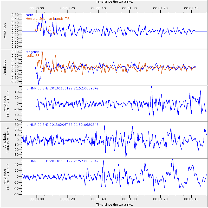
HNR Honiara, Solomon Islands - Earthquake Result Viewer
*The percent match for this event was below the threshold and hence no stack was calculated.
| Earthquake location: |
Southern Sumatra, Indonesia |
| Earthquake latitude/longitude: |
-1.5/100.3 |
| Earthquake time(UTC): |
2013/02/06 (037) 22:12:17 GMT |
| Earthquake Depth: |
10 km |
| Earthquake Magnitude: |
5.5 MB, 5.4 MS, 5.3 MW |
| Earthquake Catalog/Contributor: |
WHDF/NEIC |
|
| Network: |
IU Global Seismograph Network (GSN - IRIS/USGS) |
| Station: |
HNR Honiara, Solomon Islands |
| Lat/Lon: |
9.44 S/159.95 E |
| Elevation: |
100 m |
|
| Distance: |
59.8 deg |
| Az: |
99.963 deg |
| Baz: |
273.711 deg |
| Ray Param: |
$rayparam |
*The percent match for this event was below the threshold and hence was not used in the summary stack. |
|
| Radial Match: |
60.32981 % |
| Radial Bump: |
400 |
| Transverse Match: |
51.13367 % |
| Transverse Bump: |
336 |
| SOD ConfigId: |
558545 |
| Insert Time: |
2013-09-18 06:02:52.408 +0000 |
| GWidth: |
2.5 |
| Max Bumps: |
400 |
| Tol: |
0.001 |
|
Signal To Noise
| Channel | StoN | STA | LTA |
| IU:HNR:00:BHZ:20130206T22:21:52.068984Z | 0.7779832 | 4.865917E-6 | 6.2545278E-6 |
| IU:HNR:00:BH1:20130206T22:21:52.068984Z | 1.3678708 | 6.0649945E-6 | 4.433894E-6 |
| IU:HNR:00:BH2:20130206T22:21:52.068984Z | 1.2323905 | 1.0629987E-5 | 8.625501E-6 |
| Arrivals |
| Ps | |
| PpPs | |
| PsPs/PpSs | |


