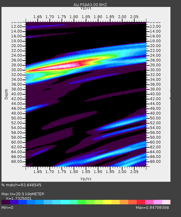
PSAA3 Pilbara Seismic Array Element A3 - Earthquake Result Viewer

Earthquake location: Santa Cruz Islands Region
Earthquake latitude/longitude: -11.7/164.9
Earthquake time(UTC): 2013/02/07 (038) 00:30:10 GMT
Earthquake Depth: 8.0 km
Earthquake Magnitude: 6.0 MB, 5.9 MS, 6.0 MW, 6.0 MW
Earthquake Catalog/Contributor: WHDF/NEIC
Network: AU Australian Seismological Centre
Station: PSAA3 Pilbara Seismic Array Element A3
Lat/Lon: 21.58 S/119.85 E
Elevation: 315 m
Distance: 44.2 deg
Az: 251.055 deg
Baz: 84.563 deg
Ray Param: 0.07208253
Estimated Moho Depth: 28.5 km
Estimated Crust Vp/Vs: 1.73
Assumed Crust Vp: 6.464 km/s
Estimated Crust Vs: 3.731 km/s
Estimated Crust Poisson's Ratio: 0.25
Radial Match: 93.646545 %
Radial Bump: 289
Transverse Match: 82.65171 %
Transverse Bump: 400
SOD ConfigId: 558545
Insert Time: 2013-09-18 06:06:02.712 +0000
GWidth: 2.5
Max Bumps: 400
Tol: 0.001

Signal To Noise

ChannelStoNSTALTA
AU:PSAA3:00:BHZ:20130207T00:37:49.093986Z14.823714.6337755E-63.1259216E-7
AU:PSAA3:00:BH1:20130207T00:37:49.093986Z1.72947262.750266E-71.5902339E-7
AU:PSAA3:00:BH2:20130207T00:37:49.093986Z15.6977342.9796074E-61.8981132E-7
Arrivals
Ps3.5 SECOND
PpPs11 SECOND
PsPs/PpSs15 SECOND