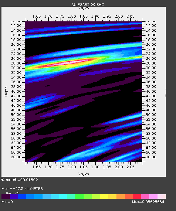
PSAB2 Pilbara Seismic Array Element B2 - Earthquake Result Viewer

Earthquake location: Santa Cruz Islands Region
Earthquake latitude/longitude: -11.7/164.9
Earthquake time(UTC): 2013/02/07 (038) 00:30:10 GMT
Earthquake Depth: 8.0 km
Earthquake Magnitude: 6.0 MB, 5.9 MS, 6.0 MW, 6.0 MW
Earthquake Catalog/Contributor: WHDF/NEIC
Network: AU Australian Seismological Centre
Station: PSAB2 Pilbara Seismic Array Element B2
Lat/Lon: 21.55 S/119.86 E
Elevation: 302 m
Distance: 44.2 deg
Az: 251.087 deg
Baz: 84.584 deg
Ray Param: 0.0720874
Estimated Moho Depth: 27.5 km
Estimated Crust Vp/Vs: 1.79
Assumed Crust Vp: 6.464 km/s
Estimated Crust Vs: 3.611 km/s
Estimated Crust Poisson's Ratio: 0.27
Radial Match: 93.01592 %
Radial Bump: 299
Transverse Match: 83.480995 %
Transverse Bump: 400
SOD ConfigId: 558545
Insert Time: 2013-09-18 06:06:08.212 +0000
GWidth: 2.5
Max Bumps: 400
Tol: 0.001

Signal To Noise

ChannelStoNSTALTA
AU:PSAB2:00:BHZ:20130207T00:37:49.043998Z15.6269694.785466E-63.0623124E-7
AU:PSAB2:00:BH1:20130207T00:37:49.043998Z13.270792.3977232E-61.8067675E-7
AU:PSAB2:00:BH2:20130207T00:37:49.043998Z11.9219651.8295685E-61.53462E-7
Arrivals
Ps3.6 SECOND
PpPs11 SECOND
PsPs/PpSs15 SECOND