You are here: Home > Network List > US - United States National Seismic Network Stations List
> Station MNTX Cornudas Mountains, Texas, USA > Earthquake Result Viewer
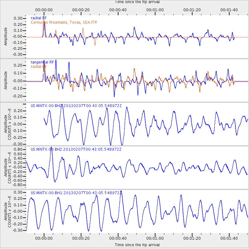
MNTX Cornudas Mountains, Texas, USA - Earthquake Result Viewer
*The percent match for this event was below the threshold and hence no stack was calculated.
| Earthquake location: |
Santa Cruz Islands Region |
| Earthquake latitude/longitude: |
-11.7/164.9 |
| Earthquake time(UTC): |
2013/02/07 (038) 00:30:10 GMT |
| Earthquake Depth: |
8.0 km |
| Earthquake Magnitude: |
6.0 MB, 5.9 MS, 6.0 MW, 6.0 MW |
| Earthquake Catalog/Contributor: |
WHDF/NEIC |
|
| Network: |
US United States National Seismic Network |
| Station: |
MNTX Cornudas Mountains, Texas, USA |
| Lat/Lon: |
31.70 N/105.38 W |
| Elevation: |
404 m |
|
| Distance: |
95.8 deg |
| Az: |
58.948 deg |
| Baz: |
259.927 deg |
| Ray Param: |
$rayparam |
*The percent match for this event was below the threshold and hence was not used in the summary stack. |
|
| Radial Match: |
56.21415 % |
| Radial Bump: |
381 |
| Transverse Match: |
75.022285 % |
| Transverse Bump: |
373 |
| SOD ConfigId: |
558545 |
| Insert Time: |
2013-09-18 06:09:06.032 +0000 |
| GWidth: |
2.5 |
| Max Bumps: |
400 |
| Tol: |
0.001 |
|
Signal To Noise
| Channel | StoN | STA | LTA |
| US:MNTX:00:BHZ:20130207T00:43:05.548972Z | 2.275299 | 4.2294545E-7 | 1.8588565E-7 |
| US:MNTX:00:BH1:20130207T00:43:05.548972Z | 1.1042577 | 1.7182242E-7 | 1.5559993E-7 |
| US:MNTX:00:BH2:20130207T00:43:05.548972Z | 0.7967126 | 1.2099936E-7 | 1.518733E-7 |
| Arrivals |
| Ps | |
| PpPs | |
| PsPs/PpSs | |


