You are here: Home > Network List > II - Global Seismograph Network (GSN - IRIS/IDA) Stations List
> Station WRAB Tennant Creek, NT, Australia > Earthquake Result Viewer
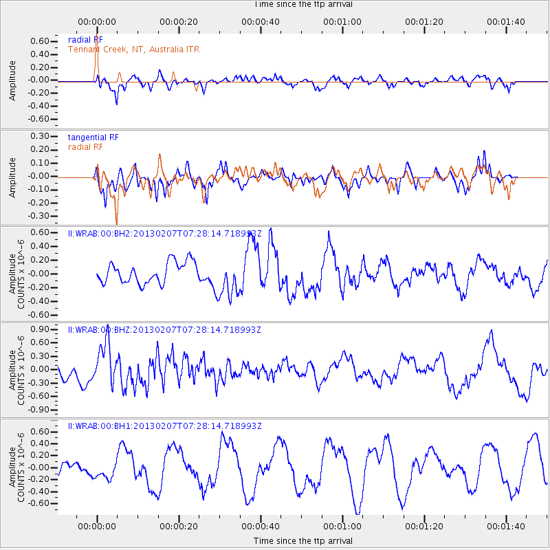
WRAB Tennant Creek, NT, Australia - Earthquake Result Viewer
*The percent match for this event was below the threshold and hence no stack was calculated.
| Earthquake location: |
Samoa Islands Region |
| Earthquake latitude/longitude: |
-15.8/-173.0 |
| Earthquake time(UTC): |
2013/02/07 (038) 07:19:51 GMT |
| Earthquake Depth: |
18 km |
| Earthquake Magnitude: |
5.8 MW, 5.6 MS, 5.7 MW |
| Earthquake Catalog/Contributor: |
NEIC PDE/NEIC PDE-W |
|
| Network: |
II Global Seismograph Network (GSN - IRIS/IDA) |
| Station: |
WRAB Tennant Creek, NT, Australia |
| Lat/Lon: |
19.93 S/134.36 E |
| Elevation: |
366 m |
|
| Distance: |
50.1 deg |
| Az: |
257.063 deg |
| Baz: |
94.245 deg |
| Ray Param: |
$rayparam |
*The percent match for this event was below the threshold and hence was not used in the summary stack. |
|
| Radial Match: |
58.5697 % |
| Radial Bump: |
400 |
| Transverse Match: |
24.784391 % |
| Transverse Bump: |
235 |
| SOD ConfigId: |
558545 |
| Insert Time: |
2013-09-18 06:10:29.572 +0000 |
| GWidth: |
2.5 |
| Max Bumps: |
400 |
| Tol: |
0.001 |
|
Signal To Noise
| Channel | StoN | STA | LTA |
| II:WRAB:00:BHZ:20130207T07:28:14.718993Z | 2.8234162 | 4.705413E-7 | 1.6665672E-7 |
| II:WRAB:00:BH1:20130207T07:28:14.718993Z | 1.141779 | 1.519406E-7 | 1.3307357E-7 |
| II:WRAB:00:BH2:20130207T07:28:14.718993Z | 1.956065 | 2.9394675E-7 | 1.5027453E-7 |
| Arrivals |
| Ps | |
| PpPs | |
| PsPs/PpSs | |


