You are here: Home > Network List > CN - Canadian National Seismograph Network Stations List
> Station DRLN Deer Lake, NFLD. > Earthquake Result Viewer
DRLN Deer Lake, NFLD. - Earthquake Result Viewer
| Earthquake location: |
Afghanistan-Tajikistan Bord Reg. |
| Earthquake latitude/longitude: |
36.4/71.1 |
| Earthquake time(UTC): |
2005/12/12 (346) 21:47:46 GMT |
| Earthquake Depth: |
225 km |
| Earthquake Magnitude: |
6.0 MB, 6.5 MW, 6.5 MW |
| Earthquake Catalog/Contributor: |
WHDF/NEIC |
|
| Network: |
CN Canadian National Seismograph Network |
| Station: |
DRLN Deer Lake, NFLD. |
| Lat/Lon: |
49.26 N/57.50 W |
| Elevation: |
238 m |
|
| Distance: |
83.3 deg |
| Az: |
328.966 deg |
| Baz: |
39.433 deg |
| Ray Param: |
0.045703858 |
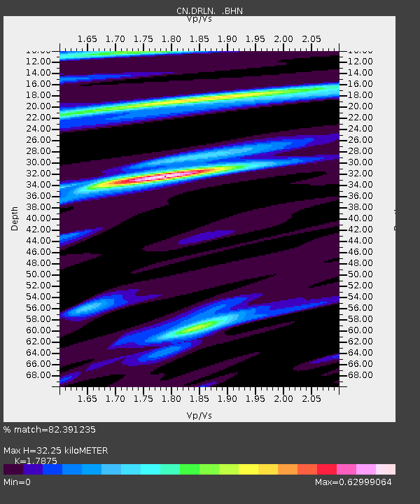
| Estimated Moho Depth: |
32.25 km |
| Estimated Crust Vp/Vs: |
1.79 |
| Assumed Crust Vp: |
6.35 km/s |
| Estimated Crust Vs: |
3.552 km/s |
| Estimated Crust Poisson's Ratio: |
0.27 |
|
| Radial Match: |
82.391235 % |
| Radial Bump: |
365 |
| Transverse Match: |
57.164608 % |
| Transverse Bump: |
400 |
| SOD ConfigId: |
2564 |
| Insert Time: |
2010-02-27 05:36:07.930 +0000 |
| GWidth: |
2.5 |
| Max Bumps: |
400 |
| Tol: |
0.001 |
|

Signal To Noise
| Channel | StoN | STA | LTA |
| CN:DRLN: :BHN:20051212T21:59:16.525017Z | 2.1362 | 1.3483179E-6 | 6.311759E-7 |
| CN:DRLN: :BHE:20051212T21:59:16.525017Z | 2.3008173 | 1.2274675E-6 | 5.334919E-7 |
| CN:DRLN: :BHZ:20051212T21:59:16.525017Z | 3.7492712 | 4.489901E-6 | 1.1975397E-6 |
| Arrivals |
| Ps | 4.1 SECOND |
| PpPs | 14 SECOND |
| PsPs/PpSs | 18 SECOND |


