You are here: Home > Network List > II - Global Seismograph Network (GSN - IRIS/IDA) Stations List
> Station KAPI Kappang, Sulawesi, Indonesia > Earthquake Result Viewer
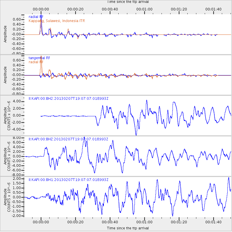
KAPI Kappang, Sulawesi, Indonesia - Earthquake Result Viewer
| Earthquake location: |
Santa Cruz Islands |
| Earthquake latitude/longitude: |
-11.0/165.7 |
| Earthquake time(UTC): |
2013/02/07 (038) 18:59:16 GMT |
| Earthquake Depth: |
11 km |
| Earthquake Magnitude: |
6.7 MW, 6.4 MB, 6.7 MW, 6.9 MS |
| Earthquake Catalog/Contributor: |
NEIC PDE/NEIC PDE-W |
|
| Network: |
II Global Seismograph Network (GSN - IRIS/IDA) |
| Station: |
KAPI Kappang, Sulawesi, Indonesia |
| Lat/Lon: |
5.01 S/119.75 E |
| Elevation: |
300 m |
|
| Distance: |
45.8 deg |
| Az: |
273.69 deg |
| Baz: |
100.405 deg |
| Ray Param: |
0.07103554 |
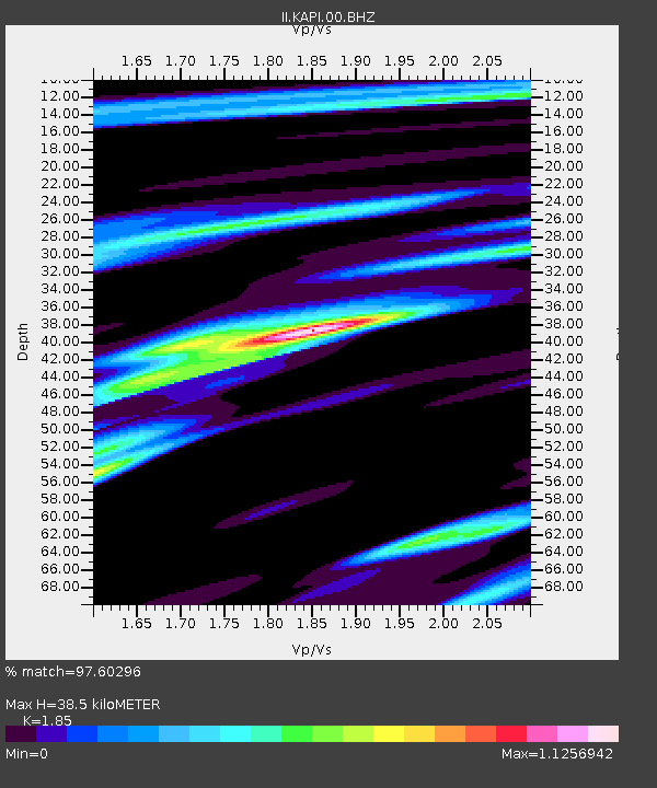
| Estimated Moho Depth: |
38.5 km |
| Estimated Crust Vp/Vs: |
1.85 |
| Assumed Crust Vp: |
6.343 km/s |
| Estimated Crust Vs: |
3.429 km/s |
| Estimated Crust Poisson's Ratio: |
0.29 |
|
| Radial Match: |
97.60296 % |
| Radial Bump: |
337 |
| Transverse Match: |
89.761154 % |
| Transverse Bump: |
400 |
| SOD ConfigId: |
558545 |
| Insert Time: |
2013-09-18 06:16:05.746 +0000 |
| GWidth: |
2.5 |
| Max Bumps: |
400 |
| Tol: |
0.001 |
|
Signal To Noise
| Channel | StoN | STA | LTA |
| II:KAPI:00:BHZ:20130207T19:07:07.018993Z | 23.978426 | 1.9890356E-6 | 8.2951054E-8 |
| II:KAPI:00:BH1:20130207T19:07:07.018993Z | 3.831181 | 1.9738928E-7 | 5.1521784E-8 |
| II:KAPI:00:BH2:20130207T19:07:07.018993Z | 20.987547 | 1.2436201E-6 | 5.925514E-8 |
| Arrivals |
| Ps | 5.5 SECOND |
| PpPs | 16 SECOND |
| PsPs/PpSs | 22 SECOND |


