You are here: Home > Network List > IU - Global Seismograph Network (GSN - IRIS/USGS) Stations List
> Station SNZO South Karori, New Zealand > Earthquake Result Viewer
SNZO South Karori, New Zealand - Earthquake Result Viewer
| Earthquake location: |
Santa Cruz Islands |
| Earthquake latitude/longitude: |
-11.0/165.7 |
| Earthquake time(UTC): |
2013/02/07 (038) 18:59:16 GMT |
| Earthquake Depth: |
11 km |
| Earthquake Magnitude: |
6.7 MW, 6.4 MB, 6.7 MW, 6.9 MS |
| Earthquake Catalog/Contributor: |
NEIC PDE/NEIC PDE-W |
|
| Network: |
IU Global Seismograph Network (GSN - IRIS/USGS) |
| Station: |
SNZO South Karori, New Zealand |
| Lat/Lon: |
41.31 S/174.70 E |
| Elevation: |
120 m |
|
| Distance: |
31.2 deg |
| Az: |
166.787 deg |
| Baz: |
342.669 deg |
| Ray Param: |
0.079123884 |
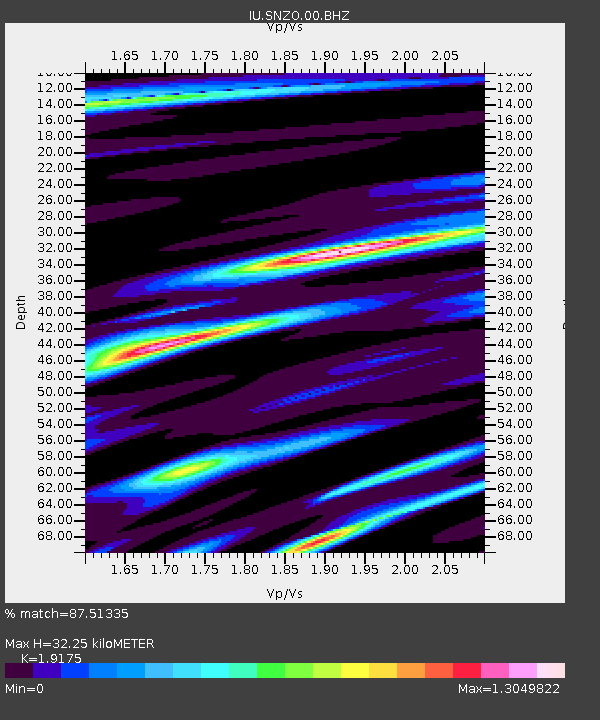
| Estimated Moho Depth: |
32.25 km |
| Estimated Crust Vp/Vs: |
1.92 |
| Assumed Crust Vp: |
6.461 km/s |
| Estimated Crust Vs: |
3.37 km/s |
| Estimated Crust Poisson's Ratio: |
0.31 |
|
| Radial Match: |
87.51335 % |
| Radial Bump: |
400 |
| Transverse Match: |
74.306465 % |
| Transverse Bump: |
400 |
| SOD ConfigId: |
558545 |
| Insert Time: |
2013-09-18 06:17:27.862 +0000 |
| GWidth: |
2.5 |
| Max Bumps: |
400 |
| Tol: |
0.001 |
|

Signal To Noise
| Channel | StoN | STA | LTA |
| IU:SNZO:00:BHZ:20130207T19:05:04.969005Z | 10.955432 | 4.909312E-6 | 4.4811668E-7 |
| IU:SNZO:00:BH1:20130207T19:05:04.969005Z | 2.0559702 | 9.512406E-7 | 4.6267235E-7 |
| IU:SNZO:00:BH2:20130207T19:05:04.969005Z | 4.6362643 | 2.1650876E-6 | 4.669897E-7 |
| Arrivals |
| Ps | 4.9 SECOND |
| PpPs | 14 SECOND |
| PsPs/PpSs | 18 SECOND |


