You are here: Home > Network List > US - United States National Seismic Network Stations List
> Station MSO Missoula, Montana, USA > Earthquake Result Viewer
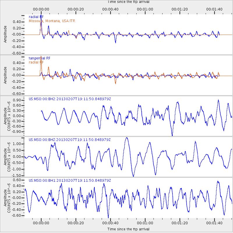
MSO Missoula, Montana, USA - Earthquake Result Viewer
*The percent match for this event was below the threshold and hence no stack was calculated.
| Earthquake location: |
Santa Cruz Islands |
| Earthquake latitude/longitude: |
-11.0/165.7 |
| Earthquake time(UTC): |
2013/02/07 (038) 18:59:16 GMT |
| Earthquake Depth: |
11 km |
| Earthquake Magnitude: |
6.7 MW, 6.4 MB, 6.7 MW, 6.9 MS |
| Earthquake Catalog/Contributor: |
NEIC PDE/NEIC PDE-W |
|
| Network: |
US United States National Seismic Network |
| Station: |
MSO Missoula, Montana, USA |
| Lat/Lon: |
46.83 N/113.94 W |
| Elevation: |
1264 m |
|
| Distance: |
91.5 deg |
| Az: |
42.627 deg |
| Baz: |
255.57 deg |
| Ray Param: |
$rayparam |
*The percent match for this event was below the threshold and hence was not used in the summary stack. |
|
| Radial Match: |
73.85474 % |
| Radial Bump: |
400 |
| Transverse Match: |
51.368637 % |
| Transverse Bump: |
400 |
| SOD ConfigId: |
558545 |
| Insert Time: |
2013-09-18 06:18:18.408 +0000 |
| GWidth: |
2.5 |
| Max Bumps: |
400 |
| Tol: |
0.001 |
|
Signal To Noise
| Channel | StoN | STA | LTA |
| US:MSO:00:BHZ:20130207T19:11:50.848979Z | 2.6808872 | 4.5555245E-7 | 1.6992601E-7 |
| US:MSO:00:BH1:20130207T19:11:50.848979Z | 0.457203 | 1.0501682E-7 | 2.2969407E-7 |
| US:MSO:00:BH2:20130207T19:11:50.848979Z | 1.23463 | 3.071477E-7 | 2.4877713E-7 |
| Arrivals |
| Ps | |
| PpPs | |
| PsPs/PpSs | |


